puerto quetzal - mexico boatingmexicoboating.com/chapter/salvador.pdf · chart), hail “puerto...
TRANSCRIPT

29
Pacific Guatemala, El Salvador, Nicaragua - 1
Here on the Pacific side, we begin after crossing Mexico’s southern border with Guatemala and move generally SE along the Central American countries of Guatemala, El Salvador, Nicaragua, Costa Rica and Pacific Panama to the Panama Canal.
This book’s companion guide, Mexico Boating Guide covers all of Pacific Mexico from the US border (Baja, Sea of Cortez, mainland Mexico) to Guatemala. See excerpts and details at www.MexicoBoating.com. The Caribbean coast of Guatemala is covered in a later chapter of Cruising Ports: the Central American Route.
Pacific GuatemalaGuatemala’s Pacific coast is only 132 n.m. long.
A Mexican Navy ship from Puerto Madero (Chiapas) stands picket off the Mexico-Guatemala border at Rio Suchiate to greet travelers in both directions.
If you’re southbounding, Guatemala’s dramatic volcano peaks welcome you. At 10 to 20 miles inland, the coastal plane rises abruptly to a string of volcano peaks. The active Volcan Fuego (13,000’) lies 35 miles NNW of Puerto Quetzal, and nearby Volcan Pocaya and may be seen at night spewing smoke and molten lava.
Between the border and Puerto Quetzal (96 miles SE), we coast 3 to 5 miles off shore. A rocky shoal is reported 5 miles out at 12 to 15 miles SE of Champerico pier (not for yatistas). Fishing nets lie
within 2.5 miles of shore as you approach the port.
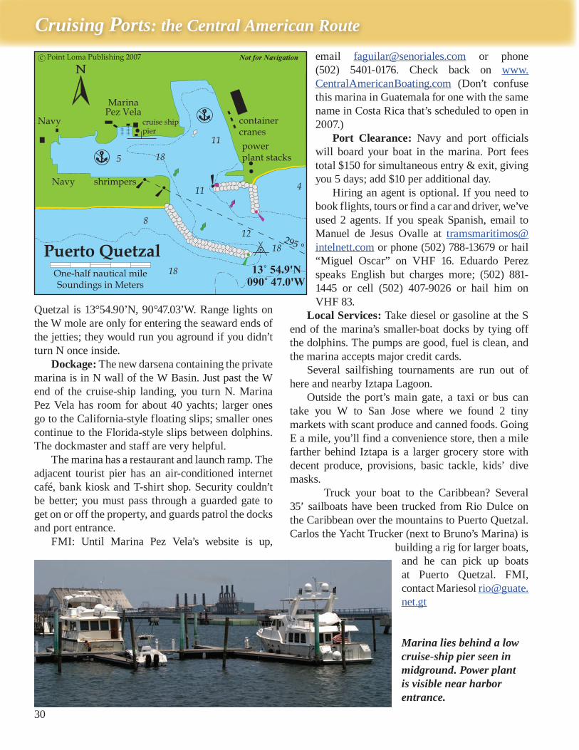
Puerto Quetzal This man-made harbor (115 miles SE of Puer-
to Madero, 150 miles WNW of Bahía Jiquilisco) is Guatemala’s main Pacific port. It has a W Basin (Navy, cruise ships, marina) and N Basin (commer-cial only). Here yatistas have access to a full-service marina with fuel dock, easy port clearance, a Navy base, grocery stores, hospital and the PanAmerican Highway.
Approach: About 2 miles west of the port’s lighted breakwaters, avoid coastal freighters moored off where the San Jose pier used to be. The port’s lighted jetties open eastward. Iztapa Lagoon has 2 tricky, shoaly entrances: the smaller lies .75 of a mile east of Puerto Quetzal, the larger about 2 miles east; but either or both may be silted closed.
When you reach the Puerto Quetzal sea buoy (See chart), hail “Puerto Quetzal Capitanía” on VHF 16, and tell them (Spanish only) you’re a yacht requesting permission to enter, and whether or not you need fuel or other services. The use of a ship’s agent is optional here, but if you want to hire one, ask the Port Captain now to contact one for you.
Anchoring is prohibited in this controlled port. You’ll be directed to enter the W Basin and take a slip in the marina.
Our GPS position in the jetty entrance to Puerto
Volcano peaks mark your approach to Pacific Guatemala.
Cruising Ports: the Central American Route
30
Quetzal is 13°54.90’N, 90°47.03’W. Range lights on the W mole are only for entering the seaward ends of the jetties; they would run you aground if you didn’t turn N once inside.
Dockage: The new darsena containing the private marina is in N wall of the W Basin. Just past the W end of the cruise-ship landing, you turn N. Marina Pez Vela has room for about 40 yachts; larger ones go to the California-style floating slips; smaller ones continue to the Florida-style slips between dolphins. The dockmaster and staff are very helpful.
The marina has a restaurant and launch ramp. The adjacent tourist pier has an air-conditioned internet café, bank kiosk and T-shirt shop. Security couldn’t be better; you must pass through a guarded gate to get on or off the property, and guards patrol the docks and port entrance.
FMI: Until Marina Pez Vela’s website is up,
email [email protected] or phone (502) 5401-0176. Check back on www.CentralAmericanBoating.com (Don’t confuse this marina in Guatemala for one with the same name in Costa Rica that’s scheduled to open in 2007.)
Port Clearance: Navy and port officials will board your boat in the marina. Port fees total $150 for simultaneous entry & exit, giving you 5 days; add $10 per additional day.
Hiring an agent is optional. If you need to book flights, tours or find a car and driver, we’ve used 2 agents. If you speak Spanish, email to Manuel de Jesus Ovalle at [email protected] or phone (502) 788-13679 or hail “Miguel Oscar” on VHF 16. Eduardo Perez speaks English but charges more; (502) 881-1445 or cell (502) 407-9026 or hail him on VHF 83.
Local Services: Take diesel or gasoline at the S end of the marina’s smaller-boat docks by tying off the dolphins. The pumps are good, fuel is clean, and the marina accepts major credit cards.
Several sailfishing tournaments are run out of here and nearby Iztapa Lagoon.
Outside the port’s main gate, a taxi or bus can take you W to San Jose where we found 2 tiny markets with scant produce and canned foods. Going E a mile, you’ll find a convenience store, then a mile farther behind Iztapa is a larger grocery store with decent produce, provisions, basic tackle, kids’ dive masks.
Truck your boat to the Caribbean? Several 35’ sailboats have been trucked from Rio Dulce on the Caribbean over the mountains to Puerto Quetzal. Carlos the Yacht Trucker (next to Bruno’s Marina) is
building a rig for larger boats, and he can pick up boats at Puerto Quetzal. FMI, contact Mariesol [email protected]
Marina lies behind a low cruise-ship pier seen in midground. Power plant is visible near harbor entrance.
31
Pacific Guatemala, El Salvador, Nicaragua - 1
Side Trips: Excellent security at Puerto Quetzal makes it a great place from which to explore Guatemala’s highlands or Altiplano for Mayan market villages, ancient pyramid ruins, historic colonial cities, active volcanoes, coffee plantations and archeological digs. Inform the dockmaster before you depart for overnight ashore. Joining a tour group or hiring a car and driver is safer and more practical than renting a car.
Antigua has dozens of Spanish schools, but we attend and recommend Proyecto Linguistico Francisco Marroquin (PLFM); visit www.langlink.com/guatemala or phone in the US (309) 692-2961. Antigua has an interesting range of small hotels, or you can room & board weekly with a family on PLFM’s list (inexpensive).
Beyond Antigua, Guatemala’s gringo trail spans Panajachel, Lago Atitlán, Huehuetenango and Chichicastenango. Avoid lingering in Guatemala City; personal security is way bad for gringos. Due to earthquakes, we avoid staying in high-rise hotels.
Iztapa LagoonJust east of Puerto Quetzal, a submarine
canyon clefts the continental shelf, and the epicenter of many earthquakes lies within 30 miles of here.
Iztapa Lagoon or the Chiquimulilla Canal has 2 shoaly, shallow, surf-prone mouths within 4 miles east of Puerto Quetzal. The narrower
mouth is only .75 of a mile east of Puerto Quetzal breakwaters; it was closed last time we looked, but being dredged. The wider mouth lies about 3 n.m. farther east. Even multihulls and shallow-draft sportfishers shouldn’t attempt these zig-zag entrances without calm seas, slack tide and a local guide on board.
In calm conditions, anchorage is possible in the open roadstead outside the lagoon, and it makes an interesting exploration by kayak or dinghy if you can hug the corners of the opening – or follow a local panga going in and out.
Inside, the main channel runs E-W for about 4 n.m. behind the wooded berm. The lagoon’s far west end has a guarded, gated community lining a maze of private channels; they don’t like visitors. In the middle of the lagoon and at the far east end are two villages with a couple fly-in sportfishing lodges (local boats, marlin & sailfish), fuel docks, shrimper piers and cantinas. Iztapa is the east village flanking Rio Iztapa.
Iztapa Lagoon lies within Monterrico Nature
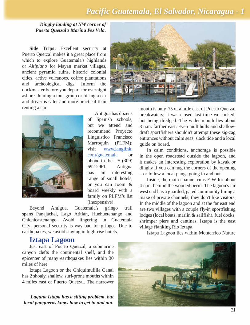
Dinghy landing at NW corner of Puerto Quetzal’s Marina Pez Vela.
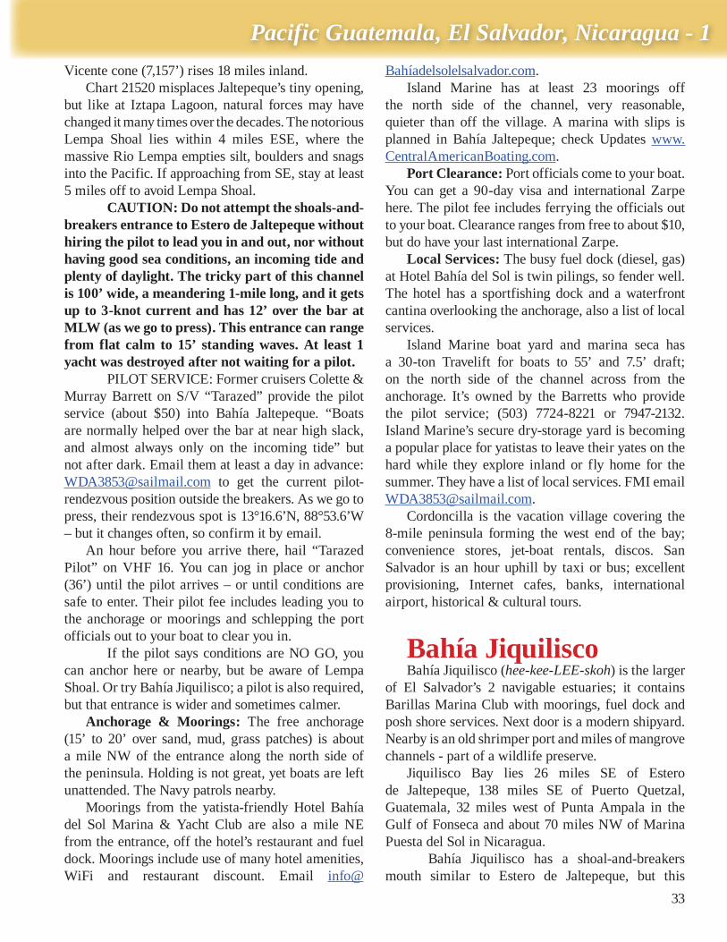
Laguna Iztapa has a silting problem, but local pangueros know how to get in and out.
Cruising Ports: the Central American Route
32
Preserve, which protects sea turtles, green iguana, the delicate mangrove iris and other flora and fauna. Kids love the Sea Turtle Center, but hours are irregular.
Iztapa Lagoon is where Juan Rodriguez Cabrillo built the ships he sailed to discover California in 1542. Those local hardwoods are now gone, and his ironworks were forged in Spain and transhipped by mule trains across Guatemala from the Caribbean side – where now a 2-lane highway winds. The lagoon’s mouths have been opened and closed many times due to silting from summer rains, pounding south swell and earthquakes (terremotos).
El SalvadorThe Republic of El Salvador is Central America’s
smallest nation (about the size of Maryland), yet it is young and densely populated (3.8 million). Since its civil war ended in 1992, El Salvador’s emerging economy has been strongly devoted to democracy, fabrication for export, agriculture and international tourism. The Salvadoran currency is the US dollar,
Spanish is the official language, and the capital city of San Salvador has the main international airport.
Geographically, El Salvador is the only Central American nation without a second coast on the Caribbean side. Its Pacific coast is 270 miles long. The Gulf of Fonseca on its SE coast also borders Honduras and Nicaragua.
El Salvador’s coastal plane is narrower than Guatemala’s, and its Pacific underwater shelf is wider and provides excellent sportfishing (marlin) and commercial shrimping. The coastal range of 20 volcanoes and mountain peaks is divided by the valley of Rio Lempa, which forms the dangerous Lempa Shoals in coastal waters.
El Salvador’s 2 yachting destinations lie close on either side of Lempa Shoal: Bahía Jaltepeque and Bahía Jiquilisco.
The Guatemala-El Salvador border at Rio Paz lies about 36 miles ESE from Puerto Quetzal. From Rio Paz, the steep, surf-pounded coastline tends SE for about 20 miles to Puerto Acajutla, on the west flank
of the coastal bulge of Punta Remedios. Puerto Acajutla is a dirty, busy container-
ship pier (13°34.4’N, 89°50.5’W). A panga darsena lies a quarter mile north of the pier, and a swell-plagued open roadstead is in between with no shelter from west or SW weather. Acajutla has nada for yatistas.
Punta Remedios: Stay at least 4 miles SSE of Punta Remedios (good radar target) due to detached Sacasa Rock and a collection of wrecks. Mountains reach the coast for the next 29 miles ESE to La Libertad open roadstead and abandoned pier.
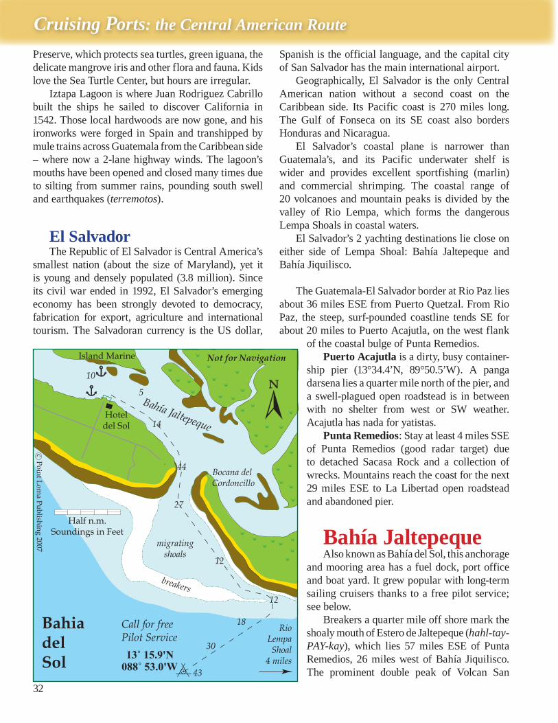
Bahía JaltepequeAlso known as Bahía del Sol, this anchorage
and mooring area has a fuel dock, port office and boat yard. It grew popular with long-term sailing cruisers thanks to a free pilot service; see below.
Breakers a quarter mile off shore mark the shoaly mouth of Estero de Jaltepeque (hahl-tay-PAY-kay), which lies 57 miles ESE of Punta Remedios, 26 miles west of Bahía Jiquilisco. The prominent double peak of Volcan San
33
Pacific Guatemala, El Salvador, Nicaragua - 1
Vicente cone (7,157’) rises 18 miles inland. Chart 21520 misplaces Jaltepeque’s tiny opening,
but like at Iztapa Lagoon, natural forces may have changed it many times over the decades. The notorious Lempa Shoal lies within 4 miles ESE, where the massive Rio Lempa empties silt, boulders and snags into the Pacific. If approaching from SE, stay at least 5 miles off to avoid Lempa Shoal.
CAUTION: Do not attempt the shoals-and-breakers entrance to Estero de Jaltepeque without hiring the pilot to lead you in and out, nor without having good sea conditions, an incoming tide and plenty of daylight. The tricky part of this channel is 100’ wide, a meandering 1-mile long, and it gets up to 3-knot current and has 12’ over the bar at MLW (as we go to press). This entrance can range from flat calm to 15’ standing waves. At least 1 yacht was destroyed after not waiting for a pilot.
PILOT SERVICE: Former cruisers Colette & Murray Barrett on S/V “Tarazed” provide the pilot service (about $50) into Bahía Jaltepeque. “Boats are normally helped over the bar at near high slack, and almost always only on the incoming tide” but not after dark. Email them at least a day in advance: [email protected] to get the current pilot-rendezvous position outside the breakers. As we go to press, their rendezvous spot is 13°16.6’N, 88°53.6’W – but it changes often, so confirm it by email.
An hour before you arrive there, hail “Tarazed Pilot” on VHF 16. You can jog in place or anchor (36’) until the pilot arrives – or until conditions are safe to enter. Their pilot fee includes leading you to the anchorage or moorings and schlepping the port officials out to your boat to clear you in.
If the pilot says conditions are NO GO, you can anchor here or nearby, but be aware of Lempa Shoal. Or try Bahía Jiquilisco; a pilot is also required, but that entrance is wider and sometimes calmer.
Anchorage & Moorings: The free anchorage (15’ to 20’ over sand, mud, grass patches) is about a mile NW of the entrance along the north side of the peninsula. Holding is not great, yet boats are left unattended. The Navy patrols nearby.
Moorings from the yatista-friendly Hotel Bahía del Sol Marina & Yacht Club are also a mile NE from the entrance, off the hotel’s restaurant and fuel dock. Moorings include use of many hotel amenities, WiFi and restaurant discount. Email info@
Bahíadelsolelsalvador.com. Island Marine has at least 23 moorings off
the north side of the channel, very reasonable, quieter than off the village. A marina with slips is planned in Bahía Jaltepeque; check Updates www.CentralAmericanBoating.com.
Port Clearance: Port officials come to your boat. You can get a 90-day visa and international Zarpe here. The pilot fee includes ferrying the officials out to your boat. Clearance ranges from free to about $10, but do have your last international Zarpe.
Local Services: The busy fuel dock (diesel, gas) at Hotel Bahía del Sol is twin pilings, so fender well. The hotel has a sportfishing dock and a waterfront cantina overlooking the anchorage, also a list of local services.
Island Marine boat yard and marina seca has a 30-ton Travelift for boats to 55’ and 7.5’ draft; on the north side of the channel across from the anchorage. It’s owned by the Barretts who provide the pilot service; (503) 7724-8221 or 7947-2132. Island Marine’s secure dry-storage yard is becoming a popular place for yatistas to leave their yates on the hard while they explore inland or fly home for the summer. They have a list of local services. FMI email [email protected].
Cordoncilla is the vacation village covering the 8-mile peninsula forming the west end of the bay; convenience stores, jet-boat rentals, discos. San Salvador is an hour uphill by taxi or bus; excellent provisioning, Internet cafes, banks, international airport, historical & cultural tours.
Bahía JiquiliscoBahía Jiquilisco (hee-kee-LEE-skoh) is the larger
of El Salvador’s 2 navigable estuaries; it contains Barillas Marina Club with moorings, fuel dock and posh shore services. Next door is a modern shipyard. Nearby is an old shrimper port and miles of mangrove channels - part of a wildlife preserve.
Jiquilisco Bay lies 26 miles SE of Estero de Jaltepeque, 138 miles SE of Puerto Quetzal, Guatemala, 32 miles west of Punta Ampala in the Gulf of Fonseca and about 70 miles NW of Marina Puesta del Sol in Nicaragua.
Bahía Jiquilisco has a shoal-and-breakers mouth similar to Estero de Jaltepeque, but this
Cruising Ports: the Central American Route
34
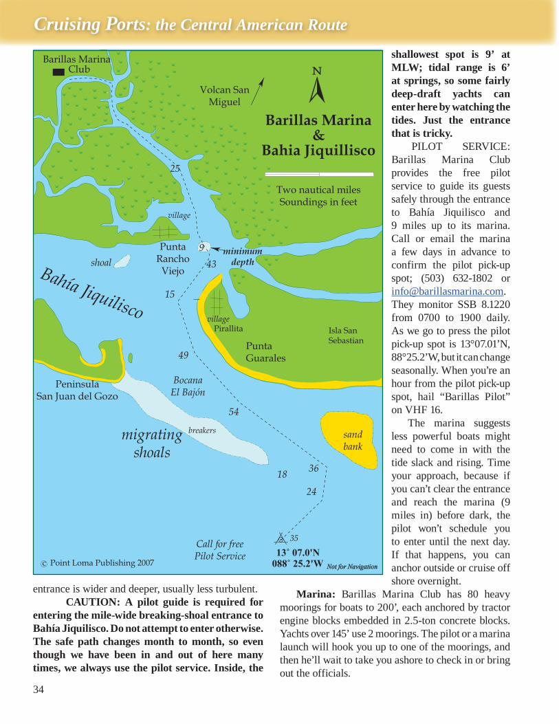
entrance is wider and deeper, usually less turbulent. CAUTION: A pilot guide is required for
entering the mile-wide breaking-shoal entrance to Bahía Jiquilisco. Do not attempt to enter otherwise. The safe path changes month to month, so even though we have been in and out of here many times, we always use the pilot service. Inside, the
shallowest spot is 9’ at MLW; tidal range is 6’ at springs, so some fairly deep-draft yachts can enter here by watching the tides. Just the entrance that is tricky.
PILOT SERVICE: Barillas Marina Club provides the free pilot service to guide its guests safely through the entrance to Bahía Jiquilisco and 9 miles up to its marina. Call or email the marina a few days in advance to confirm the pilot pick-up spot; (503) 632-1802 or [email protected]. They monitor SSB 8.1220 from 0700 to 1900 daily. As we go to press the pilot pick-up spot is 13°07.01’N, 88°25.2’W, but it can change seasonally. When you’re an hour from the pilot pick-up spot, hail “Barillas Pilot” on VHF 16.
The marina suggests less powerful boats might need to come in with the tide slack and rising. Time your approach, because if you can’t clear the entrance and reach the marina (9 miles in) before dark, the pilot won’t schedule you to enter until the next day. If that happens, you can anchor outside or cruise off shore overnight.
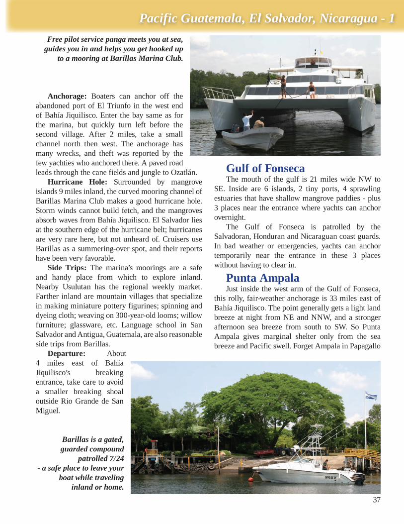
Marina: Barillas Marina Club has 80 heavy moorings for boats to 200’, each anchored by tractor engine blocks embedded in 2.5-ton concrete blocks. Yachts over 145’ use 2 moorings. The pilot or a marina launch will hook you up to one of the moorings, and then he’ll wait to take you ashore to check in or bring out the officials.
35
Pacific Guatemala, El Salvador, Nicaragua - 1
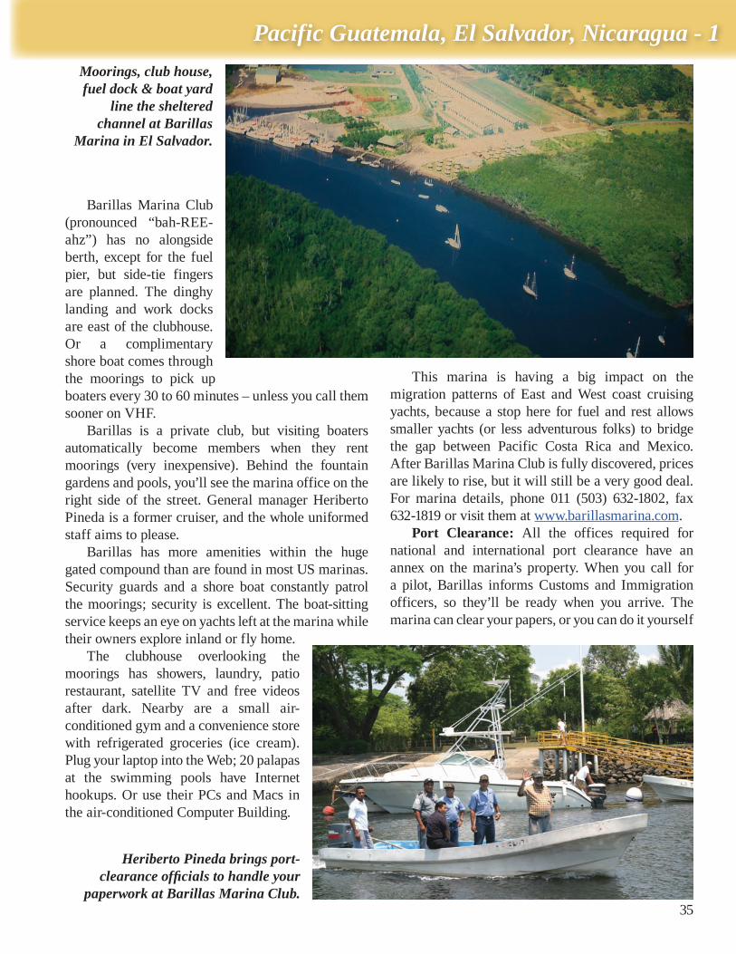
Barillas Marina Club (pronounced “bah-REE-ahz”) has no alongside berth, except for the fuel pier, but side-tie fingers are planned. The dinghy landing and work docks are east of the clubhouse. Or a complimentary shore boat comes through the moorings to pick up boaters every 30 to 60 minutes – unless you call them sooner on VHF.
Barillas is a private club, but visiting boaters automatically become members when they rent moorings (very inexpensive). Behind the fountain gardens and pools, you’ll see the marina office on the right side of the street. General manager Heriberto Pineda is a former cruiser, and the whole uniformed staff aims to please.
Barillas has more amenities within the huge gated compound than are found in most US marinas. Security guards and a shore boat constantly patrol the moorings; security is excellent. The boat-sitting service keeps an eye on yachts left at the marina while their owners explore inland or fly home.
The clubhouse overlooking the moorings has showers, laundry, patio restaurant, satellite TV and free videos after dark. Nearby are a small air-conditioned gym and a convenience store with refrigerated groceries (ice cream). Plug your laptop into the Web; 20 palapas at the swimming pools have Internet hookups. Or use their PCs and Macs in the air-conditioned Computer Building.
This marina is having a big impact on the migration patterns of East and West coast cruising yachts, because a stop here for fuel and rest allows smaller yachts (or less adventurous folks) to bridge the gap between Pacific Costa Rica and Mexico. After Barillas Marina Club is fully discovered, prices are likely to rise, but it will still be a very good deal. For marina details, phone 011 (503) 632-1802, fax 632-1819 or visit them at www.barillasmarina.com.
Port Clearance: All the offices required for national and international port clearance have an annex on the marina’s property. When you call for a pilot, Barillas informs Customs and Immigration officers, so they’ll be ready when you arrive. The marina can clear your papers, or you can do it yourself
Moorings, club house, fuel dock & boat yard
line the sheltered channel at Barillas
Marina in El Salvador.
Heriberto Pineda brings port-clearance officials to handle your
paperwork at Barillas Marina Club.
Cruising Ports: the Central American Route
36
here. Otherwise, all the offices are in Usulutan, a 45-minute drive inland.
Local Services: Basically, everything this region has to offer is supplied through the marina and its transportation services. The club’s beautifully manicured grounds are on a former coconut plantation and family farm enclosed in a high concrete wall, so all visitors must pass through a security gate with armed guards.
Barillas Marina Club is remote, 15 miles from the nearest big town and an hour’s drive from the international airport at San Salvador, the capital. But the marina’s air-conditioned van shuttles up to 8 guests to the colorful market town of Usulutan for weekly provisioning. Larger groups can use the marina’s bus and driver. See Side Trips below.
The marina’s heliport is busy, because Salvadoran club members would rather zoom over the mountains than risk the narrow, twisty highways. Barillas Marina Club’s heliport handles VIPs, and security is good. A level grass airstrip (5,576’ long, 164’ wide) handles fixed wing aircraft. You can bring your own, or the club has 2 for charter. Local members keep their boats in covered sheds near the launch ramp, and 2-story bungalows are for rent.
Fuel Dock: Texaco fuel dock in front of Barillas Marina’s clubhouse has 18’ of water at low tide and has been used by
yachts of up to 150’ length. The fuel dock has 2 well fendered pier facings, 2 pumps and 12,500 gallons of diesel delivered at high or low speed. Large quantities of oil should be ordered a day before. Credit cards are accepted, and unlike most of Mexico and Central America, no extra fee is tacked on.
Boat Yard: Just west past the marina’s fuel dock is Varadero Puerto Barillas, a large new boat yard with 3 marine ways for hauling vessels up to 125’ and 200 tons. Other services are marine-electronics sales-installation and service, all kinds of welding, shaft and prop repair, a/c and refrigeration, electrical, carpentry and fiberglass. Parts can be ordered from the US and flown into the marina next door.
The channel past the marina and boat yard has salt pans off its north side, and it curves SW around Isla Madresal then branches into the west end of Bahía Jiquilisco near the old Puerto El Triunfo. When El Salvador’s shrimp fleet berths at this boat yard, they enter and leave via the other end of this channel, not past the moored yachts. To reach Varadero Puerto Barillas boat yard, phone 011 (503) 278-3298, fax 278-3292.
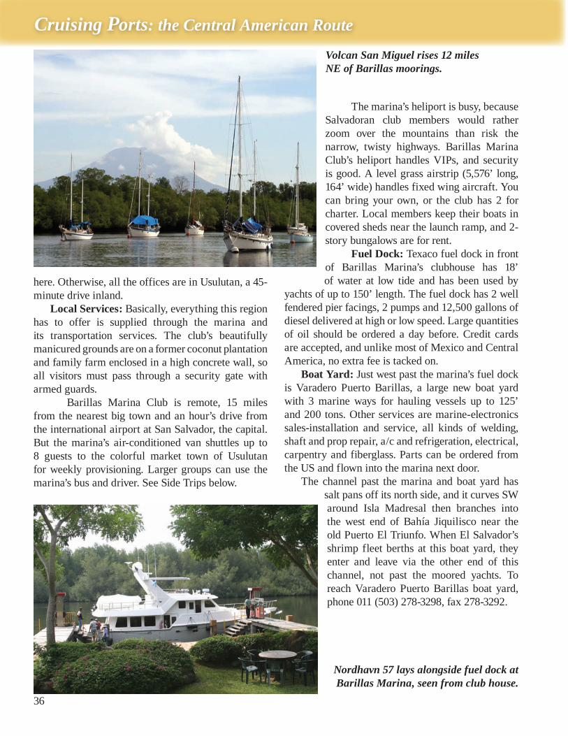
Volcan San Miguel rises 12 miles NE of Barillas moorings.
Nordhavn 57 lays alongside fuel dock at Barillas Marina, seen from club house.
37
Pacific Guatemala, El Salvador, Nicaragua - 1
Anchorage: Boaters can anchor off the abandoned port of El Triunfo in the west end of Bahía Jiquilisco. Enter the bay same as for the marina, but quickly turn left before the second village. After 2 miles, take a small channel north then west. The anchorage has many wrecks, and theft was reported by the few yachties who anchored there. A paved road leads through the cane fields and jungle to Ozatlán.
Hurricane Hole: Surrounded by mangrove islands 9 miles inland, the curved mooring channel of Barillas Marina Club makes a good hurricane hole. Storm winds cannot build fetch, and the mangroves absorb waves from Bahía Jiquilisco. El Salvador lies at the southern edge of the hurricane belt; hurricanes are very rare here, but not unheard of. Cruisers use Barillas as a summering-over spot, and their reports have been very favorable.
Side Trips: The marina’s moorings are a safe and handy place from which to explore inland. Nearby Usulutan has the regional weekly market. Farther inland are mountain villages that specialize in making miniature pottery figurines; spinning and dyeing cloth; weaving on 300-year-old looms; willow furniture; glassware, etc. Language school in San Salvador and Antigua, Guatemala, are also reasonable side trips from Barillas.
Departure: About 4 miles east of Bahía Jiquilisco’s breaking entrance, take care to avoid a smaller breaking shoal outside Rio Grande de San Miguel.
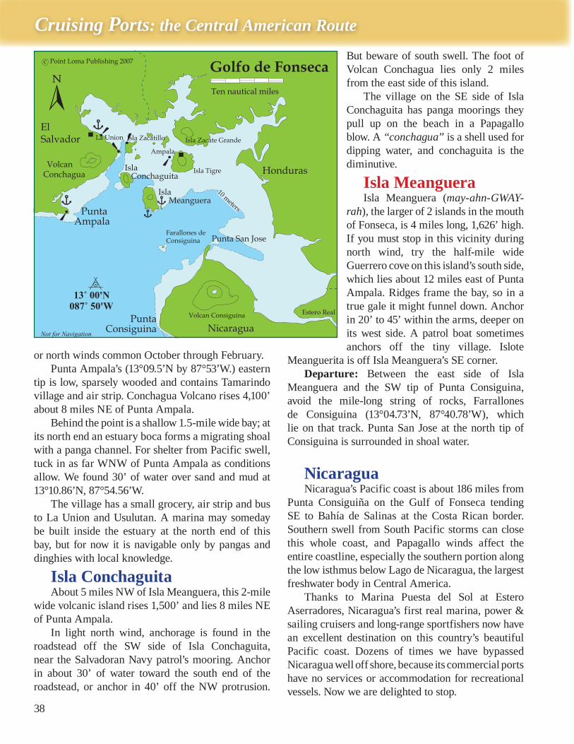
Gulf of FonsecaThe mouth of the gulf is 21 miles wide NW to
SE. Inside are 6 islands, 2 tiny ports, 4 sprawling estuaries that have shallow mangrove paddies - plus 3 places near the entrance where yachts can anchor overnight.
The Gulf of Fonseca is patrolled by the Salvadoran, Honduran and Nicaraguan coast guards. In bad weather or emergencies, yachts can anchor temporarily near the entrance in these 3 places without having to clear in.
Punta AmpalaJust inside the west arm of the Gulf of Fonseca,
this rolly, fair-weather anchorage is 33 miles east of Bahía Jiquilisco. The point generally gets a light land breeze at night from NE and NNW, and a stronger afternoon sea breeze from south to SW. So Punta Ampala gives marginal shelter only from the sea breeze and Pacific swell. Forget Ampala in Papagallo
Free pilot service panga meets you at sea, guides you in and helps you get hooked up
to a mooring at Barillas Marina Club.
Barillas is a gated, guarded compound
patrolled 7/24 - a safe place to leave your
boat while traveling inland or home.
Cruising Ports: the Central American Route
38
or north winds common October through February. Punta Ampala’s (13°09.5’N by 87°53’W.) eastern
tip is low, sparsely wooded and contains Tamarindo village and air strip. Conchagua Volcano rises 4,100’ about 8 miles NE of Punta Ampala.
Behind the point is a shallow 1.5-mile wide bay; at its north end an estuary boca forms a migrating shoal with a panga channel. For shelter from Pacific swell, tuck in as far WNW of Punta Ampala as conditions allow. We found 30’ of water over sand and mud at 13°10.86’N, 87°54.56’W.
The village has a small grocery, air strip and bus to La Union and Usulutan. A marina may someday be built inside the estuary at the north end of this bay, but for now it is navigable only by pangas and dinghies with local knowledge.
Isla ConchaguitaAbout 5 miles NW of Isla Meanguera, this 2-mile
wide volcanic island rises 1,500’ and lies 8 miles NE of Punta Ampala.
In light north wind, anchorage is found in the roadstead off the SW side of Isla Conchaguita, near the Salvadoran Navy patrol’s mooring. Anchor in about 30’ of water toward the south end of the roadstead, or anchor in 40’ off the NW protrusion.
But beware of south swell. The foot of Volcan Conchagua lies only 2 miles from the east side of this island.
The village on the SE side of Isla Conchaguita has panga moorings they pull up on the beach in a Papagallo blow. A “conchagua” is a shell used for dipping water, and conchaguita is the diminutive.
Isla MeangueraIsla Meanguera (may-ahn-GWAY-
rah), the larger of 2 islands in the mouth of Fonseca, is 4 miles long, 1,626’ high. If you must stop in this vicinity during north wind, try the half-mile wide Guerrero cove on this island’s south side, which lies about 12 miles east of Punta Ampala. Ridges frame the bay, so in a true gale it might funnel down. Anchor in 20’ to 45’ within the arms, deeper on its west side. A patrol boat sometimes anchors off the tiny village. Islote
Meanguerita is off Isla Meanguera’s SE corner.Departure: Between the east side of Isla
Meanguera and the SW tip of Punta Consiguina, avoid the mile-long string of rocks, Farrallones de Consiguina (13°04.73’N, 87°40.78’W), which lie on that track. Punta San Jose at the north tip of Consiguina is surrounded in shoal water.
NicaraguaNicaragua’s Pacific coast is about 186 miles from
Punta Consiguiña on the Gulf of Fonseca tending SE to Bahía de Salinas at the Costa Rican border. Southern swell from South Pacific storms can close this whole coast, and Papagallo winds affect the entire coastline, especially the southern portion along the low isthmus below Lago de Nicaragua, the largest freshwater body in Central America.
Thanks to Marina Puesta del Sol at Estero Aserradores, Nicaragua’s first real marina, power & sailing cruisers and long-range sportfishers now have an excellent destination on this country’s beautiful Pacific coast. Dozens of times we have bypassed Nicaragua well off shore, because its commercial ports have no services or accommodation for recreational vessels. Now we are delighted to stop.