weeeeeeeeeett - dtic
TRANSCRIPT
AD-AII8 528 CORPS OF ENGINEERS DALLAS TX SOUTHWESTERN DIV F/G 13/2
ANNUAL REPORT 1981. PART I.(U)
UNCLASSIFIED NL
I U WEEEEEEEEEEtt
vi;
4"b
A
SECURITY CLASSIFICATION4 OF THIS PiAGE (Whon Data gEntted)__________________
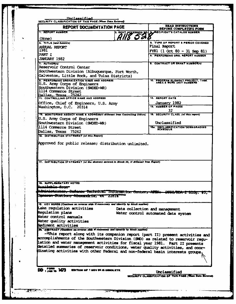
REPOT DOUM~4TATOI4 AGEBEFORE COMPLETING FORM
4. TTLE E (adSbil)S TYPE OF REPORT A PERIOD COVERED
JANNUALRPnFnlRpr
7. AUTHORfa,) OTA O-RN U9Rs
Reservoir Control CenterSouthwestern Division (Albuquerque, Fort worth,Galveston, Little Rock, and Tulsa Districts)9. PERFORMING ORGANIZATION NAME AND ADDRESS 10. PROGRAM ELEMENT. PROJECT. TASKU.S. Army Corps of Engineers AE OKUI U§R
Southwrestern Division (SWDiED-WR)1114 Camexce streetnallaQ Tpyac 75242______________11. CONTROLLING OFFICE NAME AND ADDRESS 12. REPORT DATE
Office, Chief of Engineers, U.S. Army Juay1982Washington, D.C. 20314 13. N4UMIER OFPAGES
14. MONITORING AGENCY NAME & ADORESS(If difterent heom Controlling Office) 1S. SECURITY CLASS. (of this reot)
U.S. Army Corps of Engineers1Southwestern Division (SWDVEI)-W) Unclassified1114 Carnerce Street i~a. DECLASSI FICATION/ DOWNGRADING
Dallas, Texas 75242 1 SHDL
19. DISTRIUUTION STATEMENT (of this Repert)
Aroved for public release; distribution unlimiited.
IS. SUPPIL, MEMTARY NOTES
19. KEY WORDS (Conftne en toerow #1ds it necessary end identify by Wleak nmbeir)
eregulation activities Data collection and management
ter control manualsater quality activities
tactivities*iftN. TRACT (lwso reenm eb 0 n = Me Idu " O b Week n=Ww)
3Ms report along with its companion report (part II) present activities andliskutunts of the Southwestern Division (9CD) as related to reservoir regu-
ation and water mmnaguiwnt activities for fiscal year 1981. Part ii presentsled suimaries of reservoir conditions, water quality activities, and cowr-
dnting activities with other Federal and non-federal basin interests grous.
DD pomvM 103 E3ION1 or Nov Is @MLEtE Unclassified69CcUMI V CL.ASICATIOM OF THiS PAW (M ef MSleed)
Fi
PART I
TABLE OF CONTENTS
SECTION I - INTRODUCTION PAGE
1. PURPOSE OF REPORT I-1
2. REFERENCES I-1
3. OBJECTIVES OF THE RESERVOIR CONTROL CENTER I-I
SECTION II - WATER CONTROL ACTIVITIES IN SWD
1. RESERVOIR REGULATION 1I-1
a. LAKE REGULATION DURING FY 81 I-1
b. REGULATION PLANS II-1
c. WATER CONTROL MANUALS II-1
d. SECTION 7 PROJECT REGULATION 11-2
2. SWD WATER QUALITY PROGRAM AND ACTIVITIES 11-2
a. RESPONSIBILITIES 11-2
b. ORGANIZATION Accession For 11-3
c. SPECIAL ACTIVITIES IN FY 81 DTIC TAB 11-3
d. LONG-TERM GOALS Justification I1-4
e. I2MEDIATE GOALS 1-5
3. SWD SEDIMENT PROGRAM AND ACTIVITIES 11-6
4. DATA COLLECTION AND MANAGEMENT 11-6
a. STREAM GAGING PROGRAM Di1t
b. COOPERATIVE REPORTING NETWORKS 11-6
c. CURRENT MONITORING SYSTIo 11-7
d. WATER CONTROL AUTOMATED DATA SYSTUM . 11-7
e. COOPERATIVE DATA BANK AlN) FORECASTING ACTIVITY 11-9

PART I
TABLE OF CONTENTS(CONTINUED)
PAGE
SECTION II - WATER CONTROL ACTIVITIES IN SWD (CONTINUED)
5. COORDINATION WITH WATER MANAGEMENT INTERESTS 11-9
a. INTERNAL 11-9
b. OTHER AGENCIES II-10
SECTION III - FACILITIES AND PERSONNEL
1. FACILITIES III-I
a. OFFICE SPACE III-I
b. DISPLAY FACILITIES III-I
c. CONMUNICATIONS EQUIPMENT III-l
2. PERSONNEL III-1
a. STAFF III-1
b. TRAINING Ill-1
c. TREND OF DISTRICT RESERVOIR REGULATION STAFFING III-i
ADDENDUM
MINUTES OF RCC ANNUAL MEETING Add. No. I
PLATE
DAMS AND RESERVOIRS IN THE SOUTHWESTERN DIVISION Inside Front Cover
MR- 7 7"
pilIIM

PART II
SECTION IV - STATUS OF RESERVOIR WATER CONTROL MANUALS IN SWD
SECTION V - REGULATION OF MULTI-PURPOSE PROJECTS WITH HYDROPOWER
SECTION VI - DISTRICT WATER CONTROL ACTIVITIES
1. SPECIAL RESERVOIR OPERATION
2. WATER QUALITY PROGRAM AND ACTIVITIES
3. SEDIMENT PROGRAM AND ACTIVITIES
4. COOPERATIVE PROGRAMS
SECTION VII - RESERVOIR DATA SUMMARY
1. SWD MAP
2. INDEX BY BASINS
3. INDEX IN ALPHABETHICAL ORDER
4. DATA TABLES
SECTION VIII - MEETINGS WITH BASIN INTERESTS GROUPS
I. ARKANSAS RIVER BASIN COORDINATING COMMITTEE
2. TRINITY RIVER BASIN WATER MANAGEMENT INTERESTS GROUP
* *"

tz
- -4
ZA
P. V
SECTION I - INTRODUCTION
1. PURPOSE OF REPORT. This report presents activities and accomplish-ments of the Southwestern Division (SWD) as related to reservoir regulationand water management activities through FY 1981. The companion publication,"Part II of the Annual Report", has been prepared containing detailedsummaries of reservoir conditions, water quality activities and minutesof coordinating committee meetings.
This report is prepared in conformance with ER 1110-2-1400, 24 April 1970,Reservoir Control Centers, paragraph 12c.
2. REFERENCE. Reservoir Control Center (RCC) - SWD Guidance Memorandum,dated June 1971, approved by the Chief of Engineers as a general basisfor RCC's activities.
3. OBJECTIVES OF THE RESERVOIR CONTROL CENTER. The SWD RCC was estab-
lished in 1967 by the Chief of Engineers to improve capabilities of theCorps of Engineers to perform its civil works mission as related tooperation of reservoirs. The SWD RCC carries out its responsibilities by:
a. Organizing coordinating committees and/or participating in committeesto accomplish mutual understandings among water interests regarding use andregulation of water resources.
b. Providing interbasin coordination of day-to-day regulation needsfor river systems for all purposes.
c. Surveillance of daily operations and continuous analysis of projectneeds.
d. Furnishing technical assistance to personnel of district officesin related efforts to improve the reliability of regulations and hydrologicdeterminations.
~I-I
, . ,;... . .. - 7 - . . . . - " , . ---.- - ' . ...--
SECTION II - WATER CONTROL ACTIVITIES IN SWD
1. RESERVOIR REGULATION
a. Lake Regulation During FY 81. Lake regulation activities fordivision lakes and Section 7 lakes during FY 81 are summarized in Part II,Section VI of this report. The division considers the progress made inthe development and installation of its water control automated data systemto be one of the most significant activities of the past year. For a moredetailed discussion on this activity, see paragraph 4d of this section.
Operational data summaries for all of the SWD projects, including Section 7,are shown in tabular form, two projects per page in Section VII. An index,by basin, to these tables is included which also lists pertinent data foreach project. Also included is a listing by alphabetical order giving namesof both the lake and dam where different.
b. Regulation Plans.
(1) Red River Basin. The basin system regulation studies werecontinued during the past year. Five basin conditions simulations werecompleted. These simulations represented natural basin conditions, existingbasin conditions, and three low flow conditions. A general write-up onruns completed including flow duration data were furnished the New OrleansDistrict to assist in their on-going studies for the lower Red River Basin.
(2) Trinity River Basin. Economic data were developed and includedin the existing basin model. Reservoir system plan analyses are expectedto be initiated early in calendar year 1982.
(3) Brazos River Basin. The development of a system model wasstarted during the past year. To date, the hydrology portion of the modelis complete. Initial runs are scheduled during December 1981.
c. Water Control Manuals. The latest "Status of Water Control Manualsin SWD" which is included in Part II of this report shows the status andcompletion schedule through FY 1984 for manuals on 112 lakes and 12 riversystems. At the end of FY 1981, there were 90 Corps of Engineers projects(73 lakes and 17 locks and dams) and 16 Section 7 lakes in operation inSWD. During FY 1981 impoundment began at Big Hill Lake on 31 March 1981and at El Dorado Lake on 29 June 1981.
During FY 1981 the SWD Reservoir Control Center received and reviewed elevenwater control manuals that were submitted by the districts in the form ofnew manuals, revisions to old manuals, and plans of regulation. The ReservoirControl Center continued to stress the importance of the best plan development,their documentation, and ultimately their implementation. The schedule forFY 82 includes the development of seven new manuals and the revision of manualsfor six projects.
11-I
d. Section 7 Project Regulation. Within SWD there are 16 existingreservoirs owned and operated by other agencies. Presently the Bureau ofReclamation is constructing an additional reservoir (McGee Creek) to belocated on Muddy Boggy Creek, a tributary of the Red River. The floodcontrol storage contained in these projects are regulated by the Corps inaccordance with Section 7 of the Flood Control Act of 1944. The districtsare continuing efforts to bring the manuals and regulation plans intocompliance with requirements contained in paragraph 208.11, Part 208 FloodControl Regulations, Chapter II, Title 33 of the Code of Federal Regulations(41 FR 20401, May 18, 1976). Due to the varied approaches between thedistricts on real time regulation for Section 7 projects, a SWD policystatement was formalized during 1981.
The SWD proposed policy statement was transmitted to HQDA, affected SWDDistricts, and Bureau of Reclamation regional offices in Amarillo, Texasand Denver, Colorado. It was requested that each district begin policynegotiations with their respective regional offices of the Bureau. Progressto date in policy negotiations: A meeting was held on 9 and 10 November1981 in Amarillo, Texas with the Southwest region of the Bureau. Emphasisof the meeting was the transfer of responsibility for day-to-day floodcontrol scheduling, at selected Bureau projects, from the Corps to theBureau. Also manpower, budgeting, and funding requirements were discussed.It is anticipated that additional meetings will be held during FY 82 tocontinue the negotiation process.
2. SOUTHWESTERN DAVISION WATER QUALITY PROGRAM AND ACTIVITIES.
a. Responsibilities. The RCC is assigned the responsibilities tocoordinate and direct activities in SWD in the water quality field. Thisprovides for water quality objectives being included as an effective partof our total water management program. Specific activities in the waterquality program are as follows:
(1) Conduct technical studies and provide guidance on waterquality control.
(2) Review and provide technical assistance in programs forpredicting the natural and modified water quality in impoundments, rivers,coastal areas, and estuaries for project planning, design, and regulationactivities.
(3) Review and provide technical assistance on project designand reservoir regulation studies in connection with water quality controlperformed within the division, including multiple level outlet facilities,reservoir simulation studies, reregulation structures, and release reoxy-genation systeme
(4) Provide coordination support in interagency liasion as relatedto water quality control through reservoir regulation, including formulationof operating plans and cooperative data collection programs.
11-2

(5) Coordinate with Planning and Construction-Operations Divisions,and the districts on SWD water quality investigation programs.
(6) In coordination with the Foundations and Materials Branch,manage the water quality investigation activities of the division laboratory.
(7) Responsible for technical engineering solutions to water qualityproblems in existing projects; reviewing, coordinating, and acting as consult-ants to other engineering and planning elements in the division office anddistrict offices.
(8) Coordination of division actions required by ER 1130-2-334 forreporting of water quality management of Corps projects.
b. Organization.
(1) Division. Water quality activities in SWD are coordinated bythe RCC. These duties require the part-time efforts of three engineers. Oneof these, Mr. Charles Sullivan, Chief, RCC, is a member of the OCE Committeeon Water Quality.
(2) Districts. Presently the organizations for water quality manage-ment vary within the districts. In all of the districts, water qualityassociated with planning and design of the projects is coordinated by organ-izational elements within the Engineering Division, Planning Branch, Environ-mental Resources, etc. In two of the districts the monitoring and reportingspecifically required by ER 1130-2-334 and that required for dredging andother construction are done by the Construction and Operations Divisions.
(3) Laboratory. The division laboratory is fully staffed andequipped to conduct the tests of water usually required by the districtsfor use in planning, design, construction, and operation of the projects.
c. Special Activities in FY 81.
(1) Specific Project Problems. Water quality related problems andactivities at individual projects are discussed in the district reports.Some of the more significant of these are summarized below:
(a) Addicks and Barker Reservoirs. Studies are being conductedto determine the effects of the length of impoundment of a normally dryreservoir on water quality and determine release rates to produce the mostimprovement downstream. Field work was completed in 1981 and the report willbe published later this year.
(b) Birch Lake. Studies were conducted to determine the effectsof releases from various intake levels on the downstream dissolved oxygencontent. Turbulence within the outlet works apparently raises the DO levelsto near saturation in the tailrace.
11-3
(c) Hugo Lake. A study is underway to evaluate a proposedselective level water supply intake for the City of Hugo, Oklahoma,
(d) Norfork Units 3 and 4 Feasibility Study. This study isbeing revised using more sophisticated modeling techniques to determinethe affect of pump-back units on the thermal regime in Norfork Lake andthe afterbay. Afterbay release quantities and temperatures (hourly) fromthe WES model are input into the WQRRS model to evaluate the affect onthe trout fishery.
(e) Sam Rayburn Dam. Turbine venting tests were conductedlast year to determine the effect of opening the turbine air vents onthe dissolved oxygen content in the releases. An increase in DO levelswas noted under certain conditions.
(f) Table Rock Dam DO Problem. Oxygen injection equipmentwas installed on one of the station service unit penstocks to improve theDO when the main units are off line. Tests of these facilities will continuein CY 82. The alternative solution study is continuing.
(2) Water Quality Meeting. A meeting is scheduled for 19 February1982, the day following the OCE sponsored Water Quality Seminar. The SWDLaboratory held a meeting in December 1981 to discuss laboratory facilitiesand capabilities and to present current district sampling and testingpractices.
d. Long-Term Goals. The following are presently considered as long-term, continuous goals of this division, and consequently the RCC, in thewater quality field.
(1) To obtain sufficient water quality information from all ofour projects to determine whether all state standards and environmentalobjectives can be met without adverse impact on authorized uses.
(2) To promote the organization of effective water quality elementsin the division and districts to obtain the maximum coordination forhandling all water quality matters in the division.
(3) Provide helpful and thorough guidance to the districts onwater quality matters.
(4) An SWD supplement to ER 1130-2-415, Water Quality Data Collection,Interpretation, and Application Activities, will be prepared to provide moreprecise guidance on monitoring and data collection requirements for our oper-ating projects. This will include instructions for coordination with thedivision laberatory and its role in the program and the use of other govern-mental and commerical organizations.
11-4U ..
(5) An SWD supplement to ER 1130-2-334, Reporting of Water QualityManagement Activities at Corps Civil Works Projects, will be issued toclarify and simplify the reporting required by this ER.
(6) The SWD Guide for Preparing Water Control Manuals will berevised to include more details in the water quality management sections;means available for providing downstream releases to sustain a live stream,instructions for selection of the levels from which withdrawals are made,and the preparation of realistic operation instructions pertaining tospecifying rates of changes of discharge quantities and temperatures.
e. Immediate Goals. The following actions have been scheduled foraccomplishment by the RCC in the near future,
(1) The SWDR 1130-2-9, Water Monitoring at Bathing Beaches, willbe revised to provide more specific instructions on bacteriological samplecollecting, transporting, and testing. Current applicable state and federalcriteria will be discussed, plus guidance on which to conform, in case ofdisagreement.
(2) An SWDR is being finalized to establish specific objectivesand procedures for conducting the water quality management activities atexisting SWD lakes. This will establish the division policy, outlinemonitoring requirements, water level discharge management, and budgetingand funding methods.
(3) An SWD supplement to ER 1110-2-1402, Hydrological InvestigationRequirements for Water Quality Control, will be issued. This supplementwill provide additional detailed guidance on the following items:
(a) Data necessary for determination of outlet designs forquality control, inflow and discharge quantities and frequencies, downstreamrequirements for temperature, and objectives.
(b) Instructions on how and where to present the data inplanning and design documents.
(c) Data needed for advance planning for monitoring the waterquality after construction of the project.
(d) Guidance on what specific water characteristics need tobe measured and the utilization of the division laboratory in the studies.
(4) An SWDR will be issued to provide detailed guidance on theselection of outlet works in connection with water quality management.This will cover the number and capacities of multi-level intakes, thenumber and spacing of inlet ports, operating mechanisms, and Installedequipment for monitoring. Modification of existing structures as Vellas design of new projects vill be addressed.
11-5
3. SWD SEDIMENT PROGRAM AND ACTIVITIES. In June 1981 a guidance letterwas issued to each district concerning sediment resurveys of existing reser-voir projects within SWD. The letter provided specific criteria that shouldbe met prior to scheduling and budgeting resurveys. Also, each districtwas requested to provide their resurvey schedule for the next five fiscal
years. Additional sediment activities for the past year included theapproval of Big Hill Lake DM No, 9 - sedimentation and degradation ranges,Lake Texoma resurvey, letter resurvey for John Martin Lake, and resurveyresults (Form 1787) for both John Redmond and Canton Lakes.
4. DATA COLLECTION AND MANAGEMENT.
a. Stream Gaging Program. Much of the data required for regulation,investigation and design of our water resources projects result from thereporting and measurement of flow, water quality, and sediment. Most ofthese data are obtained through a Cooperative Stream Gaging Program betweenthe Corps and the USGS. During PY 1981 the SWD-USGS cooperative programincluded 521 stations. An additional 76 stations were operated indepen-dently by the district Corps offices. In FY 81, the total cost of the SWDprogram was $1.9 million with $1.6 million being transferred to the USGS.The following tabulation shows a breakdown of the program by class of fundsused to finance the program.
Number of C of E CostClass of Funds Stations ($1,000)
Survey Investigation 10 31General Coverage 51 77Planning 10 67Operation & Maintenance 421 1,583New work & construction 30 162
TOTAL: 522* 1,920
NOTE: *Some stations are counted under more than one classification.
b. Cooperative Reporting Networks. The National Weather Service(NWS) and the Corps of Engineers began their 44th year of cooperation inestablishing and operating networks of river and/or rainfall reportingstations. Reports from these stations supplement those stations that aremaintained by the NWS which are made available to the Corps of Engineersfor flood control operations and flood forecasting.
Data from these networks are transmitted to the Corps of Engineers districtand division .,ffices via telephone and teletype service from the NWS collec-tion office. SWDO maintains teletype drops on three circuits which carrydata from these networks. One of the teletypewriters receives the FederalAviation Administration Circuit (Service C) which provides meteorologic data,river stage information and basic public weather forecasts. The other twoteletypewriters receive two circuits of the NWS RAWARC network, These twocircuits carry radar, hydrological reports, and other data essential to ourwater control management functions. These data include detailed precipitation
reports, river stage information, warnings and descriptions of severe stormsand floods, and river forecasts developed by the NWS.
11-6
The estimated FY 1981 cost for SWD responsibilities in supporting 613rainfall stations in the Cooperative Reporting Networks was $174,000,
c. Current Monitoring System. In November 1980 SWD RCC began usingthe Honeywell Computer of the ADP Center in the Southwestern Divisionoffice, for computations that are necessary in the RCC's daily watercontrol activities. Two districts are using desk-top minicomputers toassist in polling data from about 70 stations. Harris minicomputershave been installed in the SWDO and the Tulsa District as part of thewater control automated data system. The following paragraphs describecontinued efforts in developing the total system.
d. Water Control Automated Data System.
(1) The 'Water Control Data System Master Plan" for SWD, datedApril 1979 was approved by the Office, Chief of Engineers in June 1979for funding and detailed design. The major components of the system are:
(a) Remote Gaging Stations. The plan includes about 100lake gages and between 200 and 350 river gages that are to be equippedwith data collection platforms (DCP) by the end of FY 1984.
(b) Communication. The DCP's will transmit the remotegaging station data over the Geostationary Orbiting Environmental Sate-llite (GOES) System. Communication between the district and divisiondata processing units will be via telephone lines.
(c) Data Acquisition and Processing Equipment. The distrib-uted processing system dedicated to water control activities will containmini-computers located at the division office and three of the five districtoffices. Two of the districts will remote off the division machine. Theywill also be compatible in order to allow for the use of common softwareand data exchange between offices. The data bases at each district officewill be available to the division office.
(d) Data Display and Distribution. Data will be displayedin individual offices with color graphic CRT's plotters, and printers.Provisions will be made to distribute and/or exchange data with othercooperators. Examples of data exchange requirements are the Office ofChief of Engineers, Lower Mississippi Valley Division (LMVD), SouthwesternPower Administration (SWPA), state and local river authorities or agencies.
(2) During FY 81 the solicitation document for the minicomputerwas completed and issued to the vendor community for solicitation of proposals.The Hydrologic Engineering Center (HEC) at Davis, California was used toprepare and assist in running the benchmark package that was used to evaluatethe proposals. On 2 July 1981 the contract was awarded to Harris Corporationfor these machines. The contract provided for installation of this equipmentover a period covering FY 81 and FY 82. A Harris-500 minicomputer was installedin the division office in September 1981 and a Harris-500 was installed at
11-7
the Tulsa District office in October 1981. The schedule calls for install-ation of the remainder of the equipment in FY 82. This will include aHarris-500 and a Harris-100 in the Ft. Worth District, a Harris-500 andHarris-100 in the Little Rock District, and a Harris-100 in the Tulsa District.Printing terminals, CRT terminals and communication devices are being acquiredat each site on an as needed basis. Plans for software development continuedand an effort is being made to utilize existing software packages wherepossible. During FY 82, it is planned to implement the "Water Control System"software which HEC is developing for the Ohio River Division. This softwarepackage will initially be tested on the Trinity River Basin in the Ft. WorthDistrict.
(3) Design Memorandums (DM's) are to be prepared for each riverbasin showing the requirements for the DCP's for the basin. These DM'sare to include the reporting needs in the basin, schedule for installation
of the DCP's, locations, funding and maintenance plans. The DM for theArkansas-Red River Basin, Tulsa District, was submitted during FY 81.This network contains 132 stations which are to be equipped with self-timed/random DCP's. In using the NESS design criteria for random reporting, therecommended plan for this network exceeded the average of 1 "Unit Load"per station. The DM was returned to the district to evaluate the effectsof reducing the "Unit Load" to one, and how such a reduction would impactreal-time lake regulations. The problem associated with designing for a"Unit Loading" of one has been discussed with the Chief's office and NESS.Further evaluation of this problem will take place in the future. Also inFY 81 the Tulsa District was authorized to purchase 32 self-timed/adaptive-random DCP's for stations in the Arkansas-Red basin network.
(4) Funding. During FY 81 expenditures from the PRIP fund were$469,000 for the Tulsa and Dallas minicomputers. The 32 DCP's were purchasedfrom O&M and construction funds. The budget for data collection equipmentas submitted to OCE in the annual report in June is as follows:
O&M General O&M General(09 Acct) Plant Revolving (30.1 WCDS) Construction
Equip Lease Fund (PRIP) Equipment General
FY 1982 197.3 1224.1* 13.0 12.3FY 1983 280.4 633.2 125.0 20.6FY 1984 325.6 376.8 36.0 0FY 1985 345.7 15.0 31.5 27.0FY 1986 350.7 0 46.0 0
* The approved PRIP funds for FY 82 are about $300,000.
As we approach the end of the current FY, indications are that there willbe a reduction in the funds available for FY 82. Therefore, it is possiblethat some of the planned acquisitions of equipment will have to be movedinto future years.
11-8
e. Cooperative Data Bank and Forecasting Activity. During the pastyear RCC has continued to participate in and encourage the advancement ofprograms for automated data collection and interagency cooperation in
• 'forecasting activity and data bank utilization. Currently, SWD maintainsa data bank on time-share computer for Daily Lake Reports, Daily PowerGeneration Reports, and Daily River Reports. These data banks are updated
* daily and the data are maintained until the end of the month then used formonthly summaries. These data, with several district auxiliary programsand data bases, have been used to make forecasts and reports availablefor exchange as needed between the districts and SWDO. In addition, thedata are made available to other users which have a need to be aware ofthe water control activities on a real-time basis. These users includeSWPA, NWS, LMVD, and OCE. SWD has also participated in a program to developa data base for water control information for the Mississippi River Basin.
SWD districts have participated in storing data in the EPA STORET and USGSWATSTORE data banks. Both of these systems have also been used for retri-eving data. The Albuquerque and Little Rock Districts have placed waterquality data in thq EPA STORET data system and Tulsa District has placedsediment data in the OATSTORE data system.
5. COORDINATION WITH WATER MANAGEMENT INTERESTS.
a. Internal.
(1) The Hydrologic Engineering Section (the other half of theWater Management Branch) furnishes support to RCC by conducting systemsstudies of reservoir regulation.
(2) The benefits deriving from personal contact with other personsassociated with water management activities are well recognized by the RCC.For this reason, special emphasis has been placed on maintaining this personalcontact through meetings and workshops sponsored by the districts and the RCCwith the marketing agency, project personnel, river basin authorities, otherRCC's, the Chief's office and others.
(3) Future workshops will be needed for establishing criteria andimplementation procedures for comprehensive interagency data banks. Thenew automated data collection and handling equipment being acquired by theCorps and NWS will require extensive coordinating efforts over the nextfew years.
(4) A meting of lake regulation personnel of each of the districtsand the RCC is held annually at the division Reservoir Control Center forthe purpose of discussing timely topics and exchanging information. Theagenda and minutes of the meeting held on 7 October 1981 are included as Add.No. 1. The minutes suwmarize many of the current problems and accomplishmentsof the division in lake regulation activities.
U.-,
b. Other Agencies.
(1) Arkansas River Basin Coordinating Comuittee. Member organ-izations include the Corps of Engineers, SWPA, Federal Energy RegulatoryCommission (FERC), SCS, Arkansas Soil and Water Resources, Oklahoma WaterResources Board, and Kansas Water Resources Board, Chairman of the committeeis Mr. R. Terry Coomes, Chief, Water Management Branch, SWD. The annualcommittee meetings provide an opportunity for the Corps to present activities,problems, and proposed solutions regarding regulation of flows on the ArkansasRiver for maximum overall benefits. In turn, representatives of the statesand other Federal agencies may critique our activities and present theirideas and special operation proposals.
The 7 April 1981 annual meeting of the committee included a review of the1980 water control activities in the basin. In addition to the reviewother subjects covered at the meeting included the following topics:
a) Management of water quality storage in Kansas.b) Drought situation in Arkansas Basin.c) Mississippi River low water & impact on navigation in the Arkansas
Basin.d) Report on Oklahoma Comprehensive Water Plan.e) Report on mechanical problems at Webbers Falls and Ozark Power Plants.
There were also several other items discussed which were not major topics onthe program. In addition to the annual meeting, an annual report titled"Report on 1980 Activities Arkansas River Basin Coordinating Committee" wasprepared and distributed to committee members and other interested individuals.Minutes of the April 1981 meeting are included in Part II of this report.
(2) Trinity River Basin Water Management Interests Group. In orderto provide a means for exchanging ideas and coordinating the interests oflocal, state and Federal agencies and private companies in the regulationand development of water resources of the Trinity River Basin, RCC hasinitiated and sponsored meetings of the Trinity River Basin Water ManagementInterests Group.
The eleventh annual meeting of this group was held on 6 May 1981. Attendanceincluded 41 persons representing the State of Texas, several muncipalities,water districts, companies, and agencies of the Federal Government.
Presentations were made by the Corps, National Weather Service, U.S. Geo-logical Survey, Texas Department of Natural Resources, City of Denton, NorthTexas Municipal Water District, Trinity River Authority (TRA), and the TarrantCounty WC&I District. An agenda of the meeting and a list of attendees areincluded in Part II of this report.
11-10
(3) Cooperation with Mississippi Valley Division. The SWD RCC con-tinues its cooperation with NVD and provides observed, aw well as forecasteddata significant to the water management activities in MVD. Exchange of datawithin the Mississippi liver Basin has been improved by the development of aData Management System by HEC on Boeing Computer System for critical riverstations within the basin. Both forecasted and current data can be retrievedfor individual division and district use.
(4) Cooperation with Federal Energy Regulatory Comission. Periodicformal and informal contact through meetings sponsored by RC keeps Corps andFERC staff members informed on trends and problems associated with productionof hydroelectric power.
(5) Cooperation with Southwestern Power Administration. The SWPA isan agency of the United States, established in the Department of Energy, toexecute the purposes of the Flood Control Act of 1944 with respect to the dis-position of the electric power and energy made available from the reservoirprojects under control of the Department of the Army in the area comprisingall of Arkansas and Louisiana and portions of Missouri, Kansas, Texas, andOklahoma. The scheduling of releases for hyroelectric power production fromthe 17 Corps of Engineers projects within SWD has a significant effect on theoverall water management activities in the division. Therefore, close coop-eration and continuous communication between the Corps and SWPA are mandatory.A Memorandum of Understanding was signed by the SWPA and the Corps of Engi-neers last year. SWPA and SWD are in the process of developing a moredetailed operating arrangement to assist in the operations of hydropower proj-ects within SWD.
Specific activities requiring cooperation between SWPA and RCC include deter-mination of financial feasibility for power projects, monthly scheduling ofpower production, preparation of data for reports to the Federal Energy Regu-latory commission (FERC), and daily coordination of routine data on currentconditions, inflow forecasts, and release schedules. The RCC has taken everyopportunity to improve and strengthen relations with SWPA through correspon-dence, regularly scheduled and special meetings providing access to our time-share data systems, and by special studies aimed at improving energyproduction and scheduling in the SWD power projects.
II-l"
9 .. _ .. . ... .
SECTION III- FACILITIES AND PERSONNEL
1. Facilities.
a. Office Space. During February 1981, all SWD personnel were relocatedto new quarters in the Santa Fe Building, 1114 Commerce St., Dallas, Texas.Space occupied by the RCC includes an open-space working area, conferenceroom and a computer equipment room.
b. Display Facilities. All of the RCC display equipment used forconferences and for briefing of higher authorities is located in theconference room. This equipment includes a triple duty wall display unitcontaining metal chalkboards, vinyl covered cork boards, and white metalpanels adequate for grease pencil or for projection screen; various project-ion equipment, and a projection screen. In the near future, the RCC anti-cipates the remodeling of its conference room by adding additional displays,replacing old equipment, etc.
c. Communications Equipment. The computer equipment room providesspace for two 120 CPS time-share terminals, two CRT's which are hard-wired to the Harris minicomputer, magnetic tape storage, weather FAXmachine, and a small room which houses the three weather teletypes. Thetime-share terminals are used for access of SWD, Harris and Boeing computerfacilities.
2. PERSONNEL.
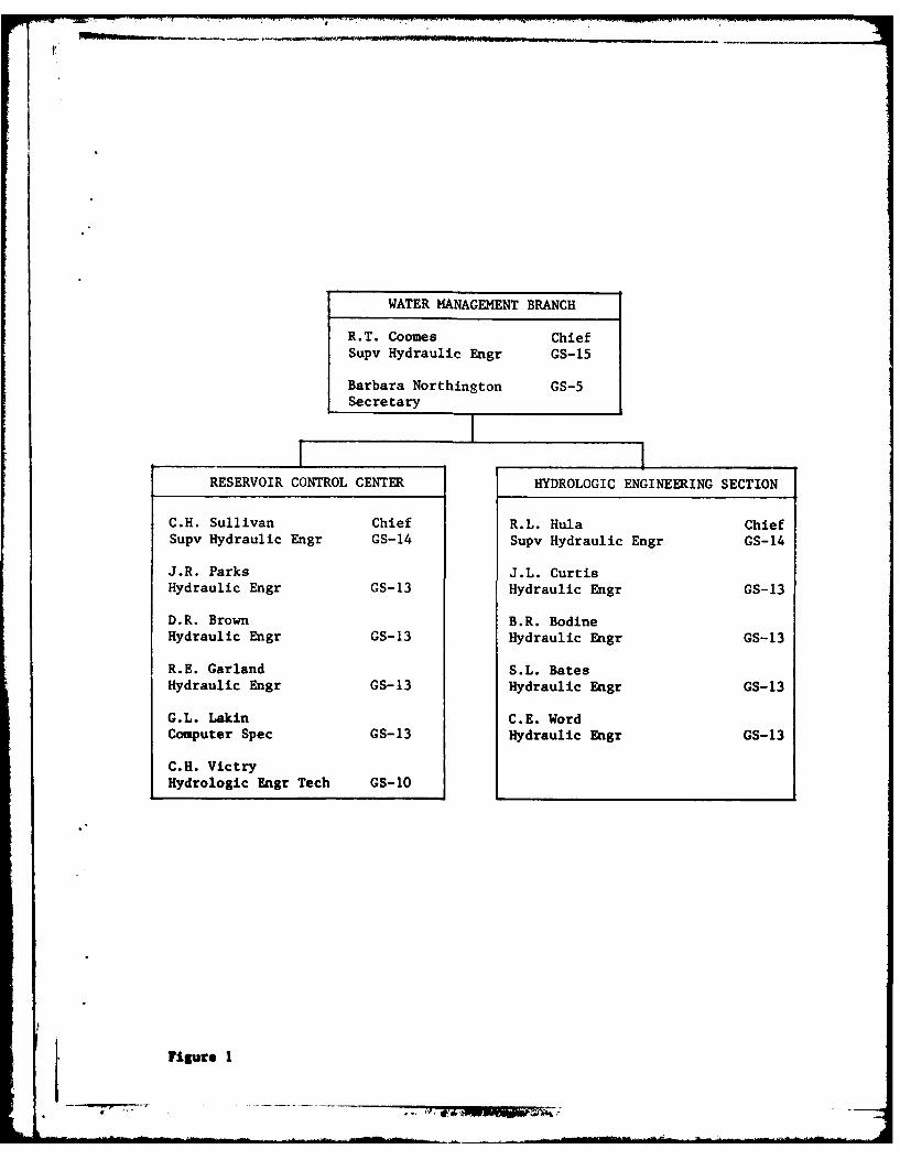
a. Staff. The current organization chart for the SWD Water ManagementBranch is shown in Figure 1. The authorized staff of RCC consists of onesupervisory hydraulic engineer, three hydraulic engineers, one computerspecialist, and one hydrologic engineering technician. The RCC is supportedby the Hydrologic Engineering Section in technical studies.
b. Training. The RCC periodically assesses the training needs of itspersonnel and schedules that training which is required and desirable formaintaining expertise and capability to fulfill its mission. Scheduledtraining for the immediate future includes various hydrologic and managementcourses.
Additional training objectives are accomplished through active participationand leadership by RCC personnel in committees such as the Arkansas RiverBasin Coordinating Committee, the Red and Trinity River Basin Water Manage-ment Interests Groups, and the Corps of Engineers Committee on Water Quality.
c. Trend of District Reservoir Reulation Staffing. The number ofpeople in the districts assigned to water control activities continues todecrease, while the number of projects are increasing. This points outthe need for continuing study of *ays to increase efficiency by automationand other means.
III-I
WATER MANAGEMENT BRANCH
R.T. Coomes ChiefSupv Hydraulic Engr GS-15
Barbara Northington GS-5Secretary
RESERVOIR CONTROL CENTER HYDROLOGIC ENGINEERING SECTION
C.H. Sullivan Chief R.L. Hula ChiefSupv Hydraulic Engr GS-14 Supv Hydraulic Engr GS-14
J.R. Parks J.L. CurtisHydraulic Engr GS-13 Hydraulic Engr GS-13
D.R. Brown B.R. BodineHydraulic Engr GS-13 Hydraulic Engr GS-13
R.E. Garland S.L. BatesHydraulic Engr GS-13 Hydraulic Engr GS-13
G.L. Lakin C.E. WordComputer Spec GS-13 Hydraulic Engr GS-13
C.H. VictryHydrologic Engr Tech GS-1O
Figure 1
el
~~AA
Y;' -g
'7 - 4:, f ' W. 4 ."
MinutesAnnual Meeting
Reservoir Control Center7 October 1981
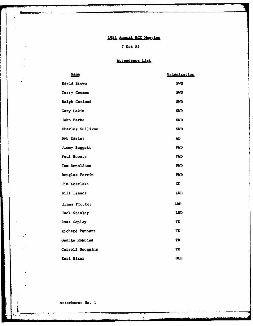
1. Introduction. The 1981 Annual Reservoir Control Center meeting washeld on 7 October 1981 in Dallas, Texas. The meeting was attended byrepresentatives from OCE, SWD and each district office. The attendancelist and the agenda are inclosed as attachments 1 and 2, respectively.
Mr. Charles Sullivan, Chief of the Reservoir Control Center (RCC), startedthe meeting by summarizing the items contained on the agenda. He pointedout the similarity of the present meeting agenda and the one for the 1980meeting, which means that we are still facing some of the same problems.
2. District Status Reports.
a. Albuquerque District. Mr. Easley reported that there were noflood operations during the year. Due to the very dry spring months, theMiddle Rio Grande Conservancy District borrowed water from the City ofAlbuquerque for irrigation. Water quality activities were essentially thesame as for the past year. Monthly readings for pH, DO and temperaturewere taken downstream of the dams when releases were being made. Parametersmeasured in the lakes were surface pH, turbidity and DO-temperature profiles.Biological samples are tested monthly at Cochiti and intermittently at otherlakes. The district has one person trained to use the recently purchasedgas chromatograph. Base line testing for dissolved nitrogen will beginduring the 1982 spring runoff. Testing for hardness and sulfate is alsoplanned for Santa Rosa. Revised area-capacity data for Trinidad and JohnMartin Lakes were implemented during FY 81. Pevised data are based on FY80 resurveys.
A special study for the Rio Grande River was completed during FY 81 andcopies of the study are available. The study was done by Lt. Col. PeterF. Lagasse of the U.S. Military Academy in West Point. The report assessesthe impact of lake operations of Cochiti on the Rio Grande channel betweenthe dam and Isleta. Other sediment activities included a study by Simons,Li and Associated of Ft. Collins, Colorado. A final draft of the reporthas been submitted to the district. The report covers a 100-year periodwhich analyzed the effect of existing projects on the Middle Rio GrandeProject. User Manuals for computer programs used in this study will bemade available for other users. Cooperative programs:
(1) The Climatic Program with National Weather Service was unchanged.
(2) The Cooperative Stream Gaging Program with the U.S.G.S. covers43 stations.
All local protection projects stations have been discontinued. Mr. Easleystated this program has been reduced to its minimum.
t1
Water Control Manuals for Cochiti and Santa Rosa Lakes were approved duringthe past year. Three additional manuals are scheduled for completion duringFY 82.
b. Fort Worth District. Mr. Thomas Donaldson led the discussion bysummarizing significant activities of the past year. Drought like conditionscontinued from 1980 and lasted for a portion of FY 81. Heavy rainfall occurredduring May and June which ended the drought for most watersheds wit' .n thedistrict. Runoff from these rains caused two flood control projects to riseinto their flood control pools. These two newly constructed projects, George-town and Granger Lakes, located on the San Gabriel River, utilized 67 and56 percent of their flood control storage, respectively. A new plan of
regulation (operating rule curve for conservation storage) for Sam RayburnReservoir was presented and adopted in a meeting held in the district officein February 1981. Representatives from the Lower Neches Valley Authority,
Gulf States Utilities, and the Southwestern Power Administration were inattendance. The plan was implemented on the basis that the plan would remaineffective until such time a permanent salt water barrier is installed on thelower Neches River. To date, the plan has been successful. Over the pastyear there were thirteen (13) requests to deviate from approved plans ofregulation. One notable deviation was for the reduction of regulated releasesfor Granger Lake. When flood releases were initiated from this newly construc-ted project, it was found that design regulated releases overflowed the down-stream channel and entered into an old slough. These releases caused somedamage to a county road and created problems for four landowners in thelower San Gabriel River Basin. After inspection by district personnel initialregulated releases were resumed.
Activities related to the FWD portion of the Water Control Data System (WCDS)were reported as follows:
(1) Thirty Satellite Data Collection Platforms (DCP) were installedin the Trinity River Basin by COMSAT General, contractor for the U.S.G.S.The contract is to be terminated early in calendar year 1982. At this time,the disposition of the DCP's has not been decided. If the PCP's are disman-tled, the district will have to reinstall them at a rate of approximately$1,000 per site.
(2) The district installed an additional six DCP's during FY 81which brings the total to 26. Presently it takes about 1.5 hours to retrievedata from these sites. Installation of the remaining 48 DCP's will be initiatedduring the upcoming year.
Mr. Jimmy Baggett reported on special problems and other activities of thedistrict. The initial filling plans for both North Fork and Georgetown Lakeswere tested, slow and rapid filling, without embankment problems. He statedthat the district had not received funds for the FY 82 Dam Assurance Program.He also stated that the district did not anticipate personnel problems forthe H & H Branch for the next year. At the conclusion of FWD's report, Mr.Sullivan emphasized the need for getting DCP's installed and that the install-ation requires an approved IK prior to their installation.
2

c. Galveston District. The district experienced one large flood
during the past year. About 70 percent of the flood storage in bothAddicks and Barker Reservoirs was utilized. Mr. Kosclski reported thatthe results of spillway adequacy studies for Barker and Addicks Damswould be released to the public. He anticipated that one position inthe district's water control activities would be lost during the year.He also stated that the three year Water Quality Program for both projectswas completed. A detailed report presenting the reulsts of the study willbe available in FY 82.
d. Little Rock District. Mr. James Proctor summarized the district'swater management activities. During the past year, the district exper-ienced general drought conditions with severe drawdowns occurring at TableRock and Bull Shoals Lakes. Meetings were held with the Southwestern Power
Administration and the Arkansas Game and Fish Commission for the purposeof establishing special releases for the downstream White River TroutFishery. Navigation was hampered along the entrance channel due to periodsof low flow on the White River and extremely low stages on the MississippiRiver. Restrictions placed on tow sizes along with reduced depths essen-tially stopped barge traffic in and out of the system. As a result of theseproblems and the anticipation that these problems will continue, the districtis investigating potential long range solutions through a contract with theWaterway Experiment Station.
Flood control operations were required at all of the LRD lakes during thespring and sum-er months. The Little River System (DeQueen, Gillham,Dierks and Millwood Lakes) required the majority of the flood operations.As in the past, peak hydropower generation rates were restricted at TableRock due to low D.O. concentrations in turbine releases. Oxygen injectionequipment was installed in the house unit station in an attempt to improveD.O. Presently the system is being tested to evaluate its effectiveness.Embankment leakage at Clearwater Lake was investigated during late May by
the district Foundations and Materials Branch. The investigation wasconducted by curtailing flood releases in order for the lake level to riseto elevation 530. Since initial filling the dam has experienced somenoticeable seepage through its left abutment when lake levels exceed eleva-tion 510. Data from these tests will be used to evaluate the severity ofthe leakage which could possible require remedial actions.
Deviations from approved plans of regulations were few as compared to pastyears. Most of the deviations requested were due to navigation. TheHydropower Report on Murray L&D was submitted and approved during FY 81.
Studies continued on the White River Basin which has been in progress since1975. The purpose of the study is to investigate the feasibility of modify-ing regulation plans to provide additional flood control, water supply, etc.Sediment activities included the resurveying of about 50 percent of the 247
sediment ranges located on the main stem of the Arkansas River. 139 ranges
3
I, -
are scheduled for resurvey in FY 82. No lake surveys were made in FY 81.At this point, Mr. Coomes raised the question of the importance of rangeresurveys in respect to "leaner" O&M funds. The district felt stronglythat resurveys should be continued. Mr. Coomes also announced that thelower end of the Red River Basin has been shifted from the New OrleansDistrict to the Vicksburg District. No change in personnel is anticipated.
e. Tulsa District. Mr. Ross Copley reported on the district activitiesfor the previous year. He stated that both river basins within the districtexperienced general drought conditions.
(1) Arkansas River Basin - Flows in the Arkansas River Basin wereabout 25 percent of normal. Deliberate impoundment began on 31 March 1981for Big Hill Lake and 29 June 1981 at El Dorado Lake. Neither projectreached minimum conservation level during the year. An agreement with theKansas Board of Agriculture, Water Resources Division, for passing naturalflows through John Redmond Dam for downstream water rights was signed inAugust 1981. See item 4 for additional discussion. All three power unitsremained out of service at Webbers Falls L&D. There were no navigationtapers during FY 81.
(2) Red River Basin - For the western part of the basin, inflowswere generally well below normal with some above nnril inflows occurringduring the spring months. Inflows in the eastern part of the basin werealso below normal. They ranged from 73 percent at Pay Mayse to 88 percentat Pine Creek. However, during October and December 1980 flows were abovenormal. A seasonal pool operation was initiated at Pine Creek for thepurpose of improving fish habitat.
The district's sediment activities included the following:
Segmental Elevation - Area data and a reconnaissance survey werecompleted for John Martin.
Reconnaissance surveys for Fort Supply and Heyburn Lakes were completed.
A contract for the installation of sedimentation and degradation rangesfor El Dorado Lake was initiated.
Installation of end monuments and the initial survey for Clayton Lakewere completed. The remaining monuments will be installed in FY 82.
Suspended sediment samples were collected at 17 sites.
3. Water Control Data System.
a. Update of System Master Manual. Mr. John Parks gave a discussion
on the requirements for updating the SWD system master manual, showed slidesof data collection platforms (DCP) and their component parts, and gave abrief status report on the system.
(1) Master plan update will primarily include the software planand schedule. During the process of the plan update, the GOES dataretrieval method should be reevaluated. The GOES data retrieval wasinitially recommended as using lease lines. Since that proposal, thecost of telephone usage has escalated to the point where downlinks maybe a viable alternative. A further check of the schedule for platforminstallation should be made to see if schedules are still valid.
(2) Master plan update milestones:
a) Draft of master plan update - mid Dec 81
b) Final typing of plan - Jan 82
c) Submittal of final plan update to OCE - Feb 82
(3) System status:
a) SWD and TD minicomputers installed in FY 81.
b) FWD and LRD minicomputers to be installed in FY 82.
c) Presently about 100 DCP's have been purchased with 450recommended in the system master plan.
d) Channel assignments have been received from OCE. Itwas cautioned that the arrangement of assigned channels should be closelyinspected to assure desired sequences. This topic led to a general discus-sion on the proposed arrangement between the Corps and NESS for channelassignments. The general concensus is that the present arrangement isunsatisfactory for the Corps needs. In-as-much as present NESS criteriaonly allow a one unit load. Mr. Eiker stated that scheduled DM's onfield installations could possibly be used as a vehicle to encourage NESSto relax their criteria on system loadings. At the conclusion of thediscussion, Mr. Sullivan reemphasized the importance of evaluating down-links as an alternative to lease lines for the GOES data retrieval system.
b. Software Planning and Development Group. Mr. James Proctor,chairman, highlighted the group's activities as follows:
(1) The group's initial meeting was held on 15 and 16 Sep 81.
(2) The purpose of the committee is to formulate a softwaredevelopment plan based on users needs and to serve as a continuing usersinterface with the specialists that develop the software.
(3) Immediate objective: Develop the plan and update the softwareportion of the Water Control Data System master plan for submission to OCEon or before 1 Feb 82.
5
(4) Plan concept:
a) Some data products (software programs) needs are commonto nearly all users and should be developed as system software.
b) Other needs may not be as readily developed as an imme-diate part of the system software and may have to be developed by indivi-dual users.
c) A two part priority list will be incorporated into theplan:
1. Common data products to all users for immediate
development.
2. User specific products that will be developed byindividual district or division office.
d) Develop data products software for use in a structuredprogramming concept such as represented by the WHAMO concept as presentedby the previous "Task Force".
e) As programming for the system and district prioritylistings progresses the system software package may be expanded, or revised,to take advantage of programming performed by specific users or to includeadditional data products that appear to be capable of development forcommon use.
f) The data base design concept and data access prioritieswill be established at an early stage so all programming whether at systemlevel or at specific user level will be based on a common data base approach.
(5) Development of software:
a) Technical subcommittee for system packages and intensive
coordination among the various user elements to assure all needs are beingmet without duplication of effort.
b) Continuing interaction of the user committee members andthe technical subcommittee to review progress relative to user needs andprovide user oriented input in the actual programming.
c) User specific programming will also be in progress, keyedto the data base design concept and with an eye to the possibility thatthe user specific program may eventually become a part of the system programpackage.
6"
In summary, the immediate need is a total estimate of time and cost forthe system software. The estimate is to be provided by the technicalgroup and will be included in the updated master manual. Mr. Proctorrequested concurrance with the group's efforts and requested that eachdistrict dedicate manpower for the system software development.
c. Application Programs that are being made available by SWD onSystem. Mr. Gary Lakin led the discussion by stating there are severalHarris machines that are being used within the Corps and SWD shouldutilize available software. Availability of existing software was pre-sented through the use of viewgraph transparencies (VGT's). See attach-ments Nos. 3 through 8. During the VGT presentation, it was recommendedthat each district have one active representative with a membership tothe Harris User's Group (HUE). Hr. Lakin also stated that HEC programsare available on the Harris system.
4. Progress Report on Agreement for Passing Downstream Water Rightsthrough Corps Projects. Mr. Carroll Scoggins, Chief of Hydrology-Hydraulics Branch, Tulsa District, discussed an existing agreementbetween the Division of Water Resources, Kansas State Board of Agri-culture and the U.S. Army Corps of Engineers. This agreement discussedthe bypassing of natural flows of the Neosho River through John RedmondDam and Reservoir. The agreement will be observed for a one year period.If favorable, the agreement will be continued and will serve as basisfor negotiating such an agreement with the State of Oklahoma.
5. Status of System Regulation Studies. Hr. Word gave the status ofpresent model development for the following river basins:
a. Arkansas River Basin. SWD has revised the model to include anadditional 20 reservoirs, 21 control points, and has extended the modeldown to Lock and Dam No. 2. The length of record still contains 35 yearsof record (1940-1974).
b. White River Basin. The model continued to be utilized by theLittle Rock District for planning purposes. The model data base contains35 years of flow records (1940-1974), has 7 reservoirs, 18 control pointsand good economic data.
c. Red River Basin. During the past year a total of five river basincondition runs were completed. These were natural, existing, and three
*" low flow conditions. Summaries of these runs were provided to the NewOrleans District for support in their on-going studies of the Lower RedRiver Basin.
d. Trinity River Basin. During FY 81 the Fort Worth District developedeconomic data for inclusion in the basin model. The data base consists of30 years (1940-1969) of daily flows with 15 reservoirs, 29 control pointsand extends to the Romayor Gage on the main stem of the Trinity. An evalua-tion of the existing condition run is expected to be complete in December1981.
7
e. Brazos River Basin. SWD developed routing criteria during thepast year. The hydrology portion of the model was developed from flowdata that were obtained from the FWD and the USGS. Initial runs areanticipated to be completed during December 1981.
Mr. Word expressed concern for two major problem areas that have beenencountered in model development and analysis. These are: 1) The lackof establishment of priorities and 2) Frequent "turn-over" of districtpersonnel that have gained experience in the use of the program and analysisof model results. The discussion on system regulation studies was concludedwith the districts providing comments and their study priorities:
Fort Worth District - With the loss of the LBL system, what are theimpacts on the use of the "Super" program? Make runs using the SWD Harriswater mini computer. Also, SWD will probably be able to man runs for thedistrict if funds are provided. FWD's priority study for FY 82 is theTrinity River Basin system, with a goal of completing the existing andnatural conditions runs during December 1981.
Tulsa District - Additional runs for the Red River Basin system duringFY 82 will depend upon the availability of district manpower.
Little Rock District - Three runs to be made for the White River Basinwith no anticipation of additional runs during FY 82.
6. SWD Policy - Section 7 Reservoirs. Mr. Sullivan led a discussion onthe continued SWD policy development and coordination activities with theBureau of Reclamation. He gave each attendee a copy of SWD's policy lettersand highlighted the content of these letters by stating that:
a. The purpose of SWD's policy is to unify Corps procedure and methodsin which Section 7 projects are regulated within SWD.
b. Policy negotiations with the project owner will be done at thedistrict level. Also, recommends that negotiations be done on a projectby project basis.
c. SWD policy proposes that the Corps pay for water control plan devel-opment and update, Corps direct day-to-day operations of those projectsthat affect other Corps projects, and the project owner pays for data collec-tion networks.
7. District Water Quality Activities.
a. Albuquerque District. Mr. Easley reported that the district'swater quality program is implemented by the Operations Division. Theseactivities are outlined in paragraph 2a of this report.
8

b. Fort Worth District. During the past year, data collection wasexpanded to include seventeen existing projects. Mr. Douglas Perrinfurther stated that data colleat included monitoring conditions ofboth upstream and downstream of Ck* dams. Parameters monitored includephysical, chemicalbiological, temerature, dissolved oxygen, etc.Special studies continued at Sam Rayburn Reservoir for the purpose ofalleviating low D.O. levels downstream of the dam due to turbine releases.Turbine venting tests were conducted during the summer without significantimprovement in D.O. levels. The scheduled water quality report for BenbrookLake was submitted for review and approval during the past year. The reportfor Lewisville Lake is scheduled for completion during FY 82.
c. Galveston District. Mr. Kosclski stated that the district's waterquality activities were performed by the USGS. A report on these acti-vities are scheduled for completion in FY 82 at such time the district's3 year program will be discontinued.
d. Little Rock District. Mr. Proctor reported that lake profileswere expanded to include all lakes within the LRD. Special studies duringthe past year included the continuaLion of instream flow needs, intensemonitoring program for Little River system was initiated, and D.O. studieswere continued at Table Rock Lake. The study is scheduled for completionduring FY 82. In addition to these on-going studies for FY 82, the districtplans to continue surveillance of lake water quality parameters, establisha committee to coordinate water quality activities between the Construction-Operations Division and the Engineering Division, etc.
e. Tulsa District. The district established several baseline studies.Mr. Richard Punnett continued by summarizing tests conducted during FY 81.The test studies were conducted for power projects which typically releasewater from the anoxic hypolimnetic zones during summer months. Also,similar studies were conducted for several non-hydropower projects. Specialreleases of 50 cfs were made from Denison Dam through the flood conduit on4 September 1981 to prevent a fish kill. Such releases not only preventedthe killing of fish, but improved fishing during non-generating periods.
8. Water Control Plans/Initial Reservoir Filling Plans/Flood EmergencyPlans/Emergency Contingency Plans for Corps Dams. Mr. Terry Coomes statedthat there are three separate programs with overlapping requirements.Also, stated that additional guidance will be given on these programs.He completed his discussion by providing the group with a list of floodemergency evacuation plans which have mappings scheduled for completionin FY 83.
9. Drought Contingency Plans. Other Division VCDs, etc. Mr. Riker ledthe discussion by referring to the superseded ER of 15 September 1980 andthe new ER dated 15 September 1981 covering drought contingency plans.He stated that the old ER was revised due to problems encountered in fundingand planning processes. ER 1110-2-1941 dated 15 September 1981 providespolicy and guidance for preparation of drought contingency plans as partof the Corps overall water control management activities. Mr. Eker out-lined general plan development as follows:
T96~
i0N 1 -= '' -q ow IF m1 m 1
a. Stage 1 - Water control managers should evaluate and establishlimits of flexibiljty, under existing authorities, for potential modifi-cation to regulation plans for existing project storage. Operation andMaintenance funds should be used in developing drought contingency plans.Budgeting for these plans should be at levels I or 2 and the cycle shouldbegin in FY 84. The cost of plan development and documentation shouldbe on the order of $5 to $15 K. Plan development should be scheduledalong with other water control activities and should be described in theappropriate part of the water control manual.
SWD recounended that initial studies begin for those projects where allstorage has not been committed. At this point, Mr. Elker cautionedagainst obligating storage without the use of contractual agreements.
b. Stage 2 - Upon completion of Stage 1, brief reconnaissance studiesmay be initiated to evaluate the feasibility of further action if projectsconstraints are removed. If results of the study indicate a high probab-ility to improve project performance, a detailed study should be made tosupport recommendations to Congress for modifying the project under theauthority of Section 216 of PL 91-611.
Mr. Eiker briefly summarized the status of other division water controldata systems. He recommended that SWD should contact the ORD and MRDduring software development.
10
1981 Annual RCC Meeting
7 Oct 81
Attendance List
Name Oranization
David Brown SWD
Terry Coomes SWD
Ralph Garland SWD
Gary Lakin SWD
John Parks SWD
Charles Sullivan SWD
Bob Easley AD
Ji my Baggett FWD
Paul Bowers FWD
Tom Donaldson FWD
Douglas Perrin FWD
Jim Kosclski GD
Bill Isaacs LRD
James Proctor LRD
Jack Stanley LRD
Ross Copley TD
Richard Punnett TD
George Robbins TD
Carroll Scogins TD
Earl Riker OCE
Attachment No. 1I
£1
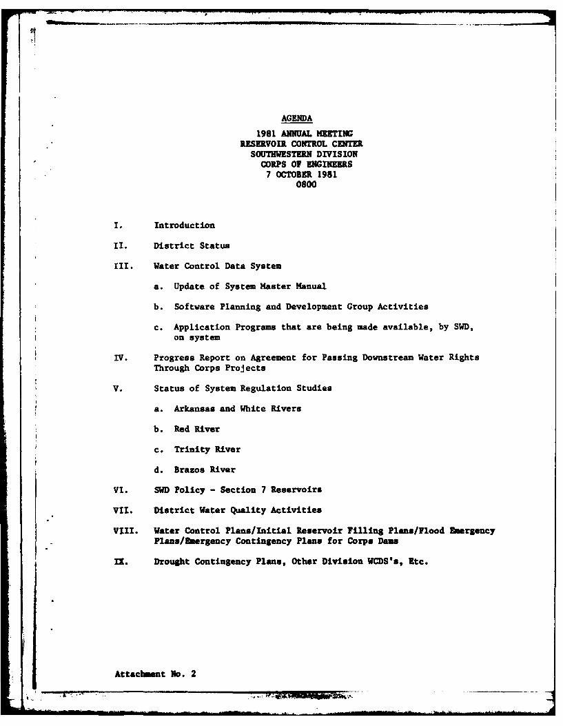
AGENDA
1981 ANNUAL MEETINGRESERVOIR CONTROL CENTER
SOUTHWESTERN DIVISIONCORPS OF ENGINEERS
7 OCTOBER 19810800
I. Introduction
ii. District Status
III. Water Control Data System
a. Update of System Master Manual
b. Software Planning and Development Group Activities
c. Application Programs that are being made available, by SWD,on system
IV. Progress Report on Agreement for Passing Downstream Water RightsThrough Corps Projects
V. Status of System Regulation Studies
a. Arkansas and White Rivers
b. Red River
c. Trinity River
d. Brazos River
VI. SWD Policy - Section 7 Reservoirs
VII. District Water Quality Activities
VIII. Water Control Plans/Initial Reservoir Filling Plans/Flood EmergencyPlans/Eergency Contingency Plans for Corps Dams
IX. Drought Contingency Plans, Other Division WCDS's, Etc.
Attachment No. 2
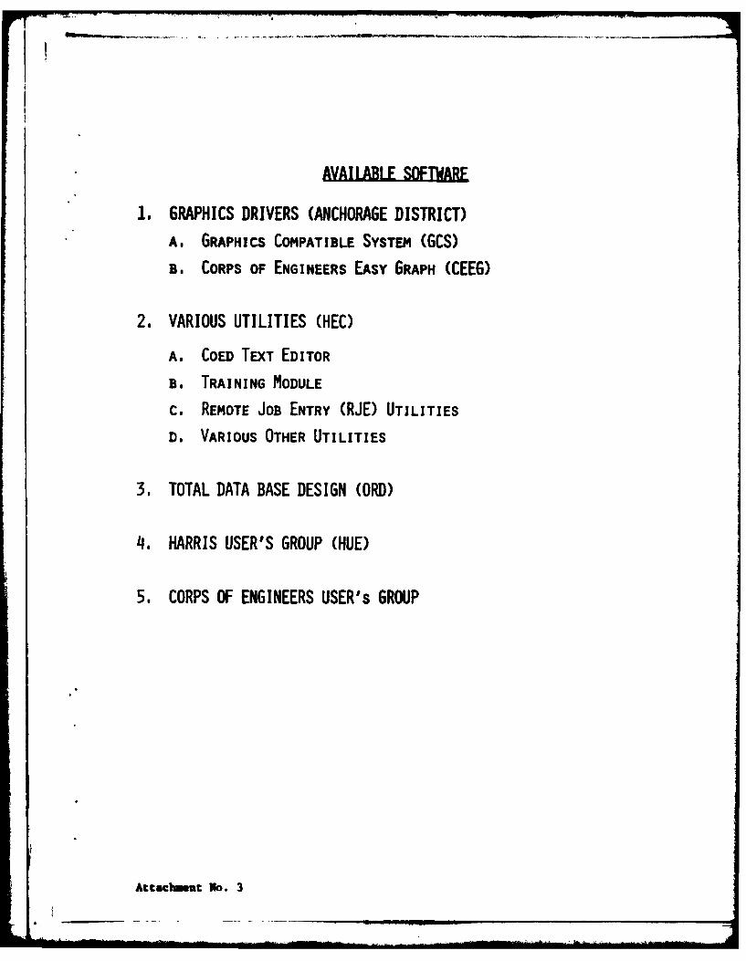
AVAILABLE SOFTWARF
1. GRAPHICS DRIVERS (ANCHORAGE DISTRICT)
A. GRAPHICS COMPATIBLE SYSTEM (GCS)
B. CORPS OF ENGINEERS EASY GRAPH (CEEG)
2. VARIOUS UTILITIES (HEC)
A. COED TEXT EDITOR
B. TRAINING MODULE
c. REMOTE JOB ENTRY (RJE) UTILITIES
D. VARIOUS OTHER UTILITIES
3. TOTAL DATA BASE DESIGN (ORD)
4I. HARRIS USER'S GROUP (HUE)
5. CORPS OF ENGINEERS USER's GROUP
Attacb t No. 3

ORD REAL TIME WATER CONTROL SYSTEM
1. BEING DEVELOPED BY HEC
2. ESTIMATE A 4.5 MANYEAR EFFORT, TO BE COMPLETE SEPTEMBER 1982
3. DATA BASE NEEDS WILL BE SATISFIED BY USE OF TOTAL DBMS AND
AZ7 QUERY SOFTWARE.
4. MODELS WILL BE DESIGNED FOR USE ON THE HARRIS 100 COMPUTER
SYSTEM.
5. MODELS WILL BE TUNED FOR A FIVE RESERVOIR RIVER BASIN IN ORD
6. SYSTEM WILL BE DIVIDED INTO TWO MAJOR FUNCTIONAL AREAS:
A. DATA MANAGEMENT MODULEB, REAL-TIME WATER CONTROL MODULE
Attachment No. 4
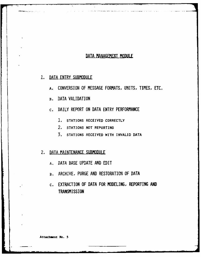
DATA MANAGEMENT MODULE
1. DATA ENTRY SUBMODULE
A. CONVERSION OF MESSAGE FORMATS, UNITS, TIMES, ETC.
B. DATA VALIDATION
c. DAILY REPORT ON DATA ENTRY PERFORMANCE
1. STATIONS RECEIVED CORRECTLY
2. STATIONS NOT REPORTING
3. STATIONS RECEIVED WITH INVALID DATA
2. DATA MAINTENANCE SUBMODULE
A. DATA BASE UPDATE AND EDIT
B. ARCHIVE, PURGE AND RESTORATION OF DATA
c. EXTRACTION OF DATA FOR MODELING, REPORTING AND
TRANSMISSION
Attachment No. 5
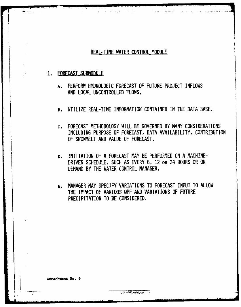
REAL-TIME WATER CONTROL MODULE
1. FORECAST SUBMODULE
A. PERFORM HYDROLOGIC FORECAST OF FUTURE PROJECT INFLOWSAND LOCAL UNCONTROLLED FLOWS.
B. UTILIZE REAL-TIME INFORMATION CONTAINED IN THE DATA BASE.
c. FORECAST METHODOLOGY WILL BE GOVERNED BY MANY CONSIDERATIONSINCLUDING PURPOSE OF FORECAST, DATA AVAILABILITY, CONTRIBUTIONOF SNOWMELT AND VALUE OF FORECAST.
D. INITIATION OF A FORECAST MAY BE PERFORMED ON A MACHINE-DRIVEN SCHEDULE, SUCH AS EVERY 6, 12 OR 24 HOURS OR ONDEMAND BY THE WATER CONTROL MANAGER.
E. MANAGER MAY SPECIFY VARIATIONS TO FORECAST INPUT TO ALLOWTHE IMPACT OF VARIOUS QPF AND VARIATIONS OF FUTUREPRECIPITATION TO BE CONSIDERED.
Attachment No. 6
I I I I I - 1 ... ....... . . .. . . . " -. ..
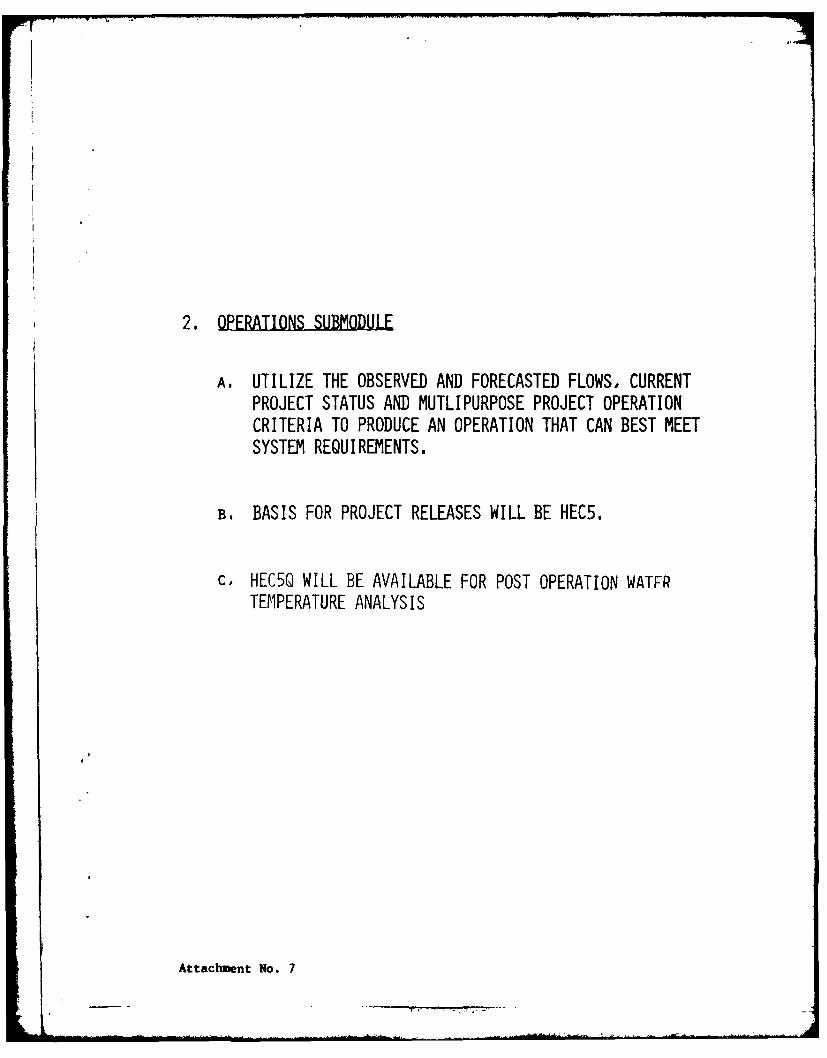
2. OPERATIONS SUBMODULE
A. UTILIZE THE OBSERVED AND FORECASTED FLOWS, CURRENTPROJECT STATUS AND MUTLIPURPOSE PROJECT OPERATIONCRITERIA TO PRODUCE AN OPERATION THAT CAN BEST MEETSYSTEM REQUIREMENTS.
B. BASIS FOR PROJECT RELEASES WILL BE HEC5.
C, HEC5Q WILL BE AVAILABLE FOR POST OPERATION WATFRTEMPERATURE ANALYSIS
Attachment No. 7
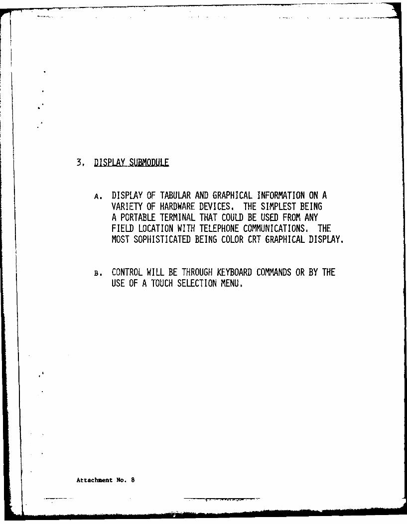
3. DISPLAY SUBMODULE
A. DISPLAY OF TABULAR AND GRAPHICAL INFORMATION ON AVARIETY OF HARDWARE DEVICES. THE SIMPLEST BEINGA PORTABLE TERMINAL THAT COULD BE USED FROM ANYFIELD LOCATION WITH TELEPHONE COMMUNICATIONS. THEMOST SOPHISTICATED BEING COLOR CRT GRAPHICAL DISPLAY.
B. CONTROL WILL BE THROUGH KEYBOARD COMMANDS OR BY THEUSE OF A TOUCH SELECTION MENU.
Attachment No. 8
P ' : i i i i . .. -I . .. + + ++ += + i+ " + n -i + i I I ....... . lll II .. .. . ...